Picture 1 of 9


Gallery
Picture 1 of 9


Have one to sell?
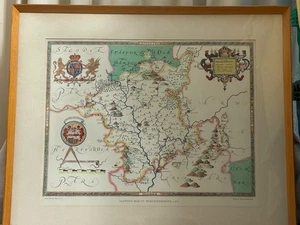
Vintage Saxton's Map of Worcestershire 1577 - Printed in 1960 by Taylowe Ltd
Condition:
Oops! Looks like we're having trouble connecting to our server.
Refresh your browser window to try again.
Shipping:
Located in: Leamington Spa, United Kingdom
Delivery:
Varies
Returns:
No returns accepted.
Coverage:
Read item description or contact seller for details. See all detailsSee all details on coverage
(Not eligible for eBay purchase protection programmes)
About this item
Seller assumes all responsibility for this listing.
eBay item number:406415571296
Item specifics
- Date Range
- 1500-1599
- Type
- County Map
- Printing Technique
- Lithography
- Year
- 1577
- Cartographer/Publisher
- Taylowe Ltd
- Original/Reproduction
- Vintage Reproduction
Item description from the seller
Seller feedback (204)
- 6***4 (1048)- Feedback left by buyer.Past 6 monthsVerified purchasePacked well and shipped quickly, great picture as described. Thank you!
- t***_ (16)- Feedback left by buyer.Past 6 monthsVerified purchasePrompt postage, well packaged. Item in good condition. Recommended seller.Gillian Wonnacott Blue Tits - Original Watercolour of Birds - Ornithological (#406109287578)
- n***n (8702)- Feedback left by buyer.Past 6 monthsVerified purchasefast delivery, safely packed, goods complies with the description, 1 a qualityWest Highland Terrier lying next to shoe - Print by Pollyanna Pickering Vintage (#406068308088)
More to explore :
- Antique European Maps & Atlases Worcestershire,
- Antique European Maps & Atlases England Worcestershire,
- Worcestershire Antique Original Antique European Maps & Atlases,
- Antique European Maps & Atlases Worcestershire 1800-1899 Date Range,
- Vintage Original 1960-1969 Date Range Antique Topographical Maps,
- Vintage Original 1960-1969 Date Range Antique County Maps,
- 1960-1969 Date Range City Map Antique North America Atlas Maps,
- 1960-1969 Date Range Antique School Maps,
- 1960-1969 Date Range Antique Topographical Maps,
- 1960-1969 Date Range Antique Folding Maps