Picture 1 of 4


Gallery
Picture 1 of 4


Have one to sell?
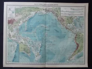
Antique Map: Pacific Ocean Cables & Depths, by George Philip, 1908
Condition:
Oops! Looks like we're having trouble connecting to our server.
Refresh your browser window to try again.
Shipping:
Located in: Hayling Island, United Kingdom
Delivery:
Varies
Returns:
No returns accepted.
Coverage:
Read item description or contact seller for details. See all detailsSee all details on coverage
(Not eligible for eBay purchase protection programmes)
Seller assumes all responsibility for this listing.
eBay item number:406290147947
Item specifics
- Date Range
- 1900-1909
- Type
- Physical Map
- Format
- Sheet Map
- Year
- 1908
- Era
- 1900s
- Map View
- Pacific Ocean
- Cartographer/Publisher
- George Philip
- Original/Reproduction
- Antique Original
Item description from the seller
Seller feedback (1,837)
- t***k (192)- Feedback left by buyer.Past 6 monthsVerified purchaseAs advertised, perfect and beautiful condition. Very nice packaging and good value. All round perfect thank you.Antique Botanical Print: Medicinal Plants, The Household Physician, 1912 (#405876636517)
- 3***3 (998)- Feedback left by buyer.Past 6 monthsVerified purchaseItem exactly as described and super quick delivery. Very pleased. Thank you.Antique Map: Thames Estuary, Kent, Essex by John Bartholomew, Survey Atlas, 1903 (#405841866478)
- t***c (4125)- Feedback left by buyer.Past 6 monthsVerified purchaseReceived as described thanksAntique Print: Metal Work from Celtic Britain, Double-sided, 1925 (#405818137325)
More to explore :
- Antique Ocean Current Maps,
- Ocean Current Map Antique Atlas Maps,
- Antique Original Antique Ocean Current Maps,
- Lithography Antique Ocean Current Maps,
- Antique World Ocean Current Maps,
- World Antique World Ocean Current Maps,
- George Cram Political Map Antique Atlas Maps,
- George Cram Antique Pull Down Maps,
- Antique European Maps & Atlases Georg Braun,
- George Cram Antique World Atlas Maps