Picture 1 of 2

Gallery
Picture 1 of 2


Have one to sell?
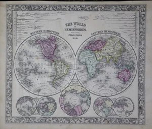
1862 Map ~ WORLD HEMISPHERES - LONGEST RIVERS by S. A. Mitchell (12x15)-#30

US $48.00
ApproximatelyRM 202.82
Condition:
“This 160-year-old map is in near pristine condition, a rare find. It is not *new* or in *new* ”... Read moreabout condition
Oops! Looks like we're having trouble connecting to our server.
Refresh your browser window to try again.
Shipping:
Free USPS Ground Advantage®.
Located in: Schertz, Texas, United States
Delivery:
Estimated between Sat, 30 Aug and Sat, 6 Sep to 94104
Returns:
30 days return. Seller pays for return shipping.
Coverage:
Read item description or contact seller for details. See all detailsSee all details on coverage
(Not eligible for eBay purchase protection programmes)
Seller assumes all responsibility for this listing.
eBay item number:406044805216
Item specifics
- Seller Notes
- Size
- the page is 12x15
- Color
- Beautiful original bright, hand tinted colors.
- Cartographer/Publisher
- S. Augustus Mitchell
- Date Range
- 1862
- Ref
- The title page is only for reference purposes. It is not included
- Type
- Wall Map
- Format
- Atlas Map
- S&H
- Free S&H USA - Calculated S&H Worldwide
- Year
- 1862
- Original/Reproduction
- Antique Original
- Country/Region
- United States of America
- Age
- over 160 years old
Item description from the seller

Seller feedback (9,711)
- i***m (433)- Feedback left by buyer.Past monthVerified purchaseJust as pictured fast shipping
- i***p (373)- Feedback left by buyer.Past monthVerified purchaseLooks great
- u***u (68)- Feedback left by buyer.Past monthVerified purchaseI wanted a map of New England for genealogy purposes. This map is perfect. Great seller. Fair price. Fast shipping. Very well packed. Parfait!!
More to explore :
- Eastern Hemisphere Antique World Atlas Maps,
- Northern Hemisphere Antique World Maps & Atlases,
- Western Hemisphere Antique World Sheet Maps,
- Western Hemisphere Antique World Physical Maps,
- Eastern Hemisphere Antique World Physical Maps,
- Eastern Hemisphere Antique World Maps & Atlases,
- Western Hemisphere Lithography Antique World Maps & Atlases,
- Eastern Hemisphere Copper Plate Antique World Sheet Maps,
- Western Hemisphere Copper Plate Antique World Maps & Atlases,
- Eastern Hemisphere Antique World Maps & Atlases 1800-1899 Date Range
Seller feedback (9,711)
- i***m (433)- Feedback left by buyer.Past monthVerified purchaseJust as pictured fast shipping
- i***p (373)- Feedback left by buyer.Past monthVerified purchaseLooks great
- u***u (68)- Feedback left by buyer.Past monthVerified purchaseI wanted a map of New England for genealogy purposes. This map is perfect. Great seller. Fair price. Fast shipping. Very well packed. Parfait!!