Picture 1 of 2

Gallery
Picture 1 of 2


Have one to sell?
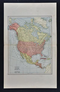
1885 Watson Map - North America - United States Canada Mexico Alaska Cuba Arctic

US $16.00
ApproximatelyRM 67.63
Was US $20.00 (20% off)
Condition:
“Very Good Condition, 11 by 15 inches (28x38cm) on a page measuring 14 by 22" (35x56cm), see the pics ”... Read moreabout condition
Sale ends in: 1d 5h
Oops! Looks like we're having trouble connecting to our server.
Refresh your browser window to try again.
Shipping:
US $4.99 (approx RM 21.09) USPS Ground Advantage®.
Located in: Fairview, Pennsylvania, United States
Delivery:
Estimated between Thu, 28 Aug and Wed, 3 Sep to 94104
Returns:
30 days return. Seller pays for return shipping.
Coverage:
Read item description or contact seller for details. See all detailsSee all details on coverage
(Not eligible for eBay purchase protection programmes)
Seller assumes all responsibility for this listing.
eBay item number:405865131875
Item specifics
- Seller Notes
- Original/Reproduction
- Antique Original
- US State
- AL, FL, GA, MS, NC, SC, AR, IA, KS, LA, MO, NE, AZ, CA, CO, NM, NV, UT, CT, MA, ME, NH, RI, VT, DC, DE, MD, NJ, NY, PA, IL, IN, MI, OH, WI, MN, MT, ND, SD, WY, OK, TX, VA, WV, KY, TN
- City
- Washington
- Type
- Political Map
- Format
- Atlas Map
- Date Range
- 1800-1899
- Canadian Province
- Alberta, British Columbia, Manitoba, New Brunswick, Newfoundland & Labrador, Northwest Territories, Nova Scotia, Ontario, Prince Edward Island, Quebec, Saskatchewan, Yukon
- Country/Region
- United States of America
- Cartographer/Publisher
- Watson
- Year
- 1885
Item description from the seller

Seller feedback (19,904)
- q***d (113)- Feedback left by buyer.Past monthVerified purchaseVery happy with my purchase overall - description, condition, delivery, everything was as expected/desired.
- q***d (113)- Feedback left by buyer.Past monthVerified purchaseVery happy with my purchase overall - description, condition, delivery, everything was as expected/desired.
- -***w (992)- Feedback left by buyer.Past monthVerified purchaseDescribed was Better than I expected. well Packaged
More to explore :
- United States of America Alaska Antique North America Geological Maps,
- United States of America Alaska Antique North America Maps & Atlases,
- Canada Alaska Antique North America Maps & Atlases,
- United States of America New Mexico Antique North America Topographical Maps,
- United States of America New Mexico Antique North America Atlas Maps,
- Yukon Canada Alaska Antique North America Maps & Atlases,
- Alaska Antique North America Topographical Maps,
- United States of America Antique North America School Maps,
- United States of America Antique North America Nautical Maps,
- United States of America Antique North America River Maps
Seller feedback (19,904)
- q***d (113)- Feedback left by buyer.Past monthVerified purchaseVery happy with my purchase overall - description, condition, delivery, everything was as expected/desired.
- q***d (113)- Feedback left by buyer.Past monthVerified purchaseVery happy with my purchase overall - description, condition, delivery, everything was as expected/desired.
- -***w (992)- Feedback left by buyer.Past monthVerified purchaseDescribed was Better than I expected. well Packaged