Picture 1 of 5


Gallery
Picture 1 of 5


Have one to sell?
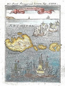
GREECE AMORGOS KINAROS "I. d'Amorgo et de Zinara" 1719 MALLET ORIG. ANTIQUE MAP

US $50.00
ApproximatelyRM 211.35
Condition:
“Very Good”
Oops! Looks like we're having trouble connecting to our server.
Refresh your browser window to try again.
Shipping:
US $32.00 (approx RM 135.26) Standard Shipping.
Located in: Reggio nell'Emilia, Italy
Delivery:
Estimated between Tue, 2 Sep and Fri, 19 Sep to 94104
Returns:
14 days return. Buyer pays for return shipping. If you use an eBay shipping label, it will be deducted from your refund amount.
Coverage:
Read item description or contact seller for details. See all detailsSee all details on coverage
(Not eligible for eBay purchase protection programmes)
Seller assumes all responsibility for this listing.
eBay item number:405535477697
Item specifics
- Seller Notes
- “Very Good”
- Date Range
- 1700-1799
- Type
- City Map
- Format
- Atlas Map
- Printing Technique
- Copper Plate
- Year
- 1719
- Original/Reproduction
- Antique Original
- Cartographer/Publisher
- A. M. Mallet
- City
- Amorgos
- Country/Region
- Greece
Item description from the seller

Seller feedback (62)
- _***_ (421)- Feedback left by buyer.Past monthVerified purchaseLlegó en perfectas condiciones y a tiempo, la pieza es tal como la esperaba
- _***_ (421)- Feedback left by buyer.Past monthVerified purchaseLlegó en perfectas condiciones y a tiempo, la pieza es tal como la esperaba
- _***_ (421)- Feedback left by buyer.Past monthVerified purchaseLlegó en perfectas condiciones y a tiempo, la pieza es tal como la esperaba
More to explore :
- Antique European Maps & Atlases Greece,
- Greece Antique Europe Topographical Maps,
- Greece Antique Europe Folding Maps,
- Greece Antique Europe Political Maps,
- Greece Antique Europe City Maps,
- Greece County Map Antique Europe Atlas Maps,
- Greece Antique Original Antique Europe Topographical Maps,
- Athens Greece Antique Europe City Maps,
- Athens Greece Lithography Antique Europe Maps & Atlases,
- Greece Copper Plate Antique Europe Folding Maps
Seller feedback (62)
- _***_ (421)- Feedback left by buyer.Past monthVerified purchaseLlegó en perfectas condiciones y a tiempo, la pieza es tal como la esperaba
- _***_ (421)- Feedback left by buyer.Past monthVerified purchaseLlegó en perfectas condiciones y a tiempo, la pieza es tal como la esperaba
- _***_ (421)- Feedback left by buyer.Past monthVerified purchaseLlegó en perfectas condiciones y a tiempo, la pieza es tal como la esperaba