Picture 1 of 4


Gallery
Picture 1 of 4


Have one to sell?
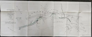
Antique 1897 Map of Oakland Harbor CA Showing Progress as of June 30th 1896

US $85.00
ApproximatelyRM 359.30
or Best Offer
Condition:
Oops! Looks like we're having trouble connecting to our server.
Refresh your browser window to try again.
Shipping:
US $4.84 (approx RM 20.46) USPS Ground Advantage®.
Located in: Tillamook, Oregon, United States
Delivery:
Estimated between Wed, 27 Aug and Tue, 2 Sep to 94104
Returns:
No returns accepted.
Coverage:
Read item description or contact seller for details. See all detailsSee all details on coverage
(Not eligible for eBay purchase protection programmes)
Seller assumes all responsibility for this listing.
eBay item number:388506951548
Item specifics
- Year
- 1896
- Date Range
- 1800-1899
- Type
- River Map
- US State
- California
- Format
- Folding Map
- Printing Technique
- Copper Plate
- Original/Reproduction
- Antique Original
- City
- oakland
- Country/Region
- United States of America
Item description from the seller

Seller feedback (25)
- e***e (454)- Feedback left by buyer.Past monthVerified purchaseItem as promised. Thank you very much.
- i***i (94)- Feedback left by buyer.Past 6 monthsVerified purchaseExcellent seller. Quick and well packaged. Item exactly as shown. Very reasonable on the price! Will use again!!
- i***w (182)- Feedback left by buyer.Past 6 monthsVerified purchaseGreat seller!Antique map showing distribution of Pinus Echinata 1891 Dept of Agriculture 10x9 (#387442666649)
More to explore :
- Antique Atlas Maps,
- Antique Original Political Map Antique Wall Maps,
- Antique Original Topographical Map Antique Wall Maps,
- Antique Original City Map Antique Atlas Maps,
- Antique Original County Map Antique School Maps,
- Antique Original Nautical Map Antique Atlas Maps,
- Antique Original County Map Antique Sheet Maps,
- Antique Original Topographical Map Antique Atlas Maps,
- Antique Original Physical Map Antique Sheet Maps,
- Antique Original Railroad Map Antique Wall Maps
Seller feedback (25)
- e***e (454)- Feedback left by buyer.Past monthVerified purchaseItem as promised. Thank you very much.
- i***i (94)- Feedback left by buyer.Past 6 monthsVerified purchaseExcellent seller. Quick and well packaged. Item exactly as shown. Very reasonable on the price! Will use again!!
- i***w (182)- Feedback left by buyer.Past 6 monthsVerified purchaseGreat seller!Antique map showing distribution of Pinus Echinata 1891 Dept of Agriculture 10x9 (#387442666649)