Picture 1 of 3


Gallery
Picture 1 of 3


Have one to sell?
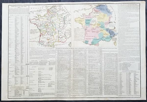
1803 Emmanuel Las Cases Large Antique Maps of France, Provinces & Territories

US $55.98
ApproximatelyRM 236.40
Condition:
Oops! Looks like we're having trouble connecting to our server.
Refresh your browser window to try again.
Shipping:
US $9.99 (approx RM 42.19) Standard Shipping from outside US.
Located in: Ivanhoe, VIC, Australia
Delivery:
Estimated between Fri, 24 Oct and Tue, 4 Nov to 94104
Returns:
14 days return. Buyer pays for return shipping. If you use an eBay shipping label, it will be deducted from your refund amount.
Coverage:
Read item description or contact seller for details. See all detailsSee all details on coverage
(Not eligible for eBay purchase protection programmes)
Seller assumes all responsibility for this listing.
eBay item number:374298630637
Item specifics
- Cartographer/Publisher
- Emmanuel Marie Joseph Las Cases
- Printing Technique
- Copper Plate
- Original/Reproduction
- Antique Original
- Format
- Atlas Map
- Type
- World Atlas
- Year
- 1803
- Date Range
- 1800-1899
- Country/Region
- France
Item description from the seller
Seller business information
VAT number: AU 54097057022

Seller feedback (6,624)
- Automatische Bewertung von eBay- Feedback left by buyer.Past monthBestellung pünktlich und problemlos geliefert
- Automatische Bewertung von eBay- Feedback left by buyer.Past monthBestellung pünktlich und problemlos geliefert
- Automatische Bewertung von eBay- Feedback left by buyer.Past monthBestellung pünktlich und problemlos geliefert
More to explore :
- Paris France Antique Maps,
- France Antique Europe Topographical Maps,
- France Antique Europe Railroad Maps,
- France Antique Europe River Maps,
- France Antique Europe Novelty Maps,
- France City Map Antique Europe Atlas Maps,
- France Topographical Map Antique Europe Atlas Maps,
- France County Map Antique Europe Atlas Maps,
- France Antique Original Antique Europe Topographical Maps,
- France Antique Original Antique Europe Folding Maps
Seller feedback (6,624)
- Automatische Bewertung von eBay- Feedback left by buyer.Past monthBestellung pünktlich und problemlos geliefert
- Automatische Bewertung von eBay- Feedback left by buyer.Past monthBestellung pünktlich und problemlos geliefert
- Automatische Bewertung von eBay- Feedback left by buyer.Past monthBestellung pünktlich und problemlos geliefert