Picture 1 of 4


Gallery
Picture 1 of 4


Have one to sell?
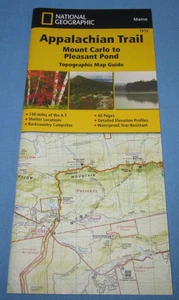
Appalachian Trail Topographic Map Guide Mount Carlo to Pleasant Pond by Nat Geo

US $11.95
ApproximatelyRM 50.50
Condition:
Brand New
A new, unread, unused book in perfect condition with no missing or damaged pages.
Oops! Looks like we're having trouble connecting to our server.
Refresh your browser window to try again.
Shipping:
Free USPS Ground Advantage®.
Located in: Temple, Georgia, United States
Delivery:
Estimated between Thu, 23 Oct and Mon, 27 Oct to 94104
Returns:
30 days return. Buyer pays for return shipping. If you use an eBay shipping label, it will be deducted from your refund amount.
Coverage:
Read item description or contact seller for details. See all detailsSee all details on coverage
(Not eligible for eBay purchase protection programmes)
Shop with confidence
Seller assumes all responsibility for this listing.
eBay item number:365874178894
Item specifics
- Condition
- Brand New: A new, unread, unused book in perfect condition with no missing or damaged pages. See all condition definitionsopens in a new window or tab
- Vintage
- No
- ISBN
- 9781597756495
About this product
Product Identifiers
Publisher
National Geographic Maps
ISBN-10
1597756490
ISBN-13
9781597756495
eBay Product ID (ePID)
215351503
Product Key Features
Edition
2022
Book Title
Appalachian Trail, Mount Carlo to Pleasant Pond [Maine]
Number of Pages
1 Pages
Language
English
Topic
Maps & Road Atlases (See Also Reference / Atlases, Gazetteers & Maps), United States / Northeast / New England (Ct, mA, Me, NH, Ri, VT), Special Interest / Hikes & Walks, Hiking
Publication Year
2022
Illustrator
Yes
Genre
Travel, Sports & Recreation
Book Series
National Geographic Topographic Map Guide Ser.
Format
Sheet Map, Folded
Dimensions
Item Weight
2.6 Oz
Item Length
9.4 in
Item Width
4.3 in
Additional Product Features
Intended Audience
Trade
Series Volume Number
1512
Synopsis
Waterproof, tear-resistant topographic map guide. The Mount Carlo to Pleasant Pond Topographic Map Guide makes a perfect traveling companion when traversing the southern Maine section of the Appalachian Trail. Each A.T. Topographic Map Guide includes detailed topographic maps at a detail of 1 inch equals 1 mile. Each page is centered on the A.T. and overlaps with the adjacent pages so there is little chance of getting lost. Along the bottom of each page is a trail profile that shows the distance between shelters, camping areas, and trail access points., - Waterproof - Tear-Resistant - Topographic Map The Mount Carlo to Pleasant Pond Topographic Map Guide makes a perfect traveling companion when traversing the southern Maine section of the Appalachian Trail (A.T.). The A.T. through Maine offers some of the most challenging sections of trail along the A.T., both in rugged terrain and weather conditions, and is not recommended for the unprepared hiker. Each A.T. Topographic Map Guide includes detailed topographic maps at a detail of 1 inch = 1 mile. Each page is centered on the A.T. and overlaps with the adjacent pages so there is little chance of getting lost. Along the bottom of each page is a trail profile that shows the distance between shelters, camping areas, and trail access points. The map and trail profile provide a step by step visual guide to hiking the trail, mile by rugged mile. The Topographic Map Guide is built for all levels of hiking enthusiasts, from the day tripper to the multi month 'thru-hiker'. The front pages of the printed Topographic Map Guide include resupply information, town inset maps, camping options, and much more. Every Topographic Map Guide is printed on "Backcountry Tough" waterproof, tear-resistant paper. A full UTM grid is printed on the map to aid with GPS navigation. Other features found on this map include: Andover, Bald Mtn Brook Shelter, Baldpate Mountain, Baldpate Shelter, Bemis Mountain, Bemis Mtn Shelter, Bigelow Mountain, Caratunk, Carlo Col Shelter, Crocker Mountain, Elephant Mountain, Frye Notch Shelter, Full Goose Shelter, Hall Mtn Shelter, Horns Pond Shelter, Kennebec River, Little Bigelow Shelter, Mahoosuc Arm, Mount Carlo, Old Blue Mountain, Piazza Rock Shelter, Pierce Pond Shelter, Pleasant Pond Mtn Bigelow Preserve, Pleasant Pond Shelter, Poplar Ridge Shelter, Sabbath Day Pond Shelter, Saddleback Mountain, Sebasticook Lake, Spaulding Mountain, Spaulding Mtn Shelter, Speck Pond Shelter, Sugarloaf Mountain, West Carry Pond Shelter, Wyman Mountain. Map Scale = 1:63,360 Folded Size = 4.25" x 9.25"
Item description from the seller

Seller feedback (41,083)
- k***n (2187)- Feedback left by buyer.Past monthVerified purchaseFast shipping which is appreciated. Well packaged, which is also appreciated since the post office and other carriers seem to destroy every package nowadays. It doesn't matter if it's USPS, UPS or Fed X, In Florida they destroy every package they handle. Almost every package i receive is either torn open, crushed, mutilated or destroyed. This product/package arrived intact, safe and undamaged because this seller packaged it well. Got a good deal and would recommend this seller.
- 5***t (345)- Feedback left by buyer.Past yearVerified purchaseVery good price. Very fast shipping. Good communication. Arrived as shown in pictures. Fast tracking number provided and shipping. Placed order on a Saturday and received tracking number within minutes. Was even shipped out on a Saturday. Case arrived cracked, but the disc was not harmed or scratched.Taxi Chaos - Sony PlayStation 4 .. sealed new for PS4 (#315293508770)
- a***y (17)- Feedback left by buyer.Past 6 monthsVerified purchaseExcellent seller, great communication, fast shipment, item well packed, brand new as described, good price, buy with confidence, thank you!Truth Hardware #93199 Cover & Handle Replacement ~ White, Right Hand Operator (#363952577747)
More to explore :
Seller feedback (41,083)
- k***n (2187)- Feedback left by buyer.Past monthVerified purchaseFast shipping which is appreciated. Well packaged, which is also appreciated since the post office and other carriers seem to destroy every package nowadays. It doesn't matter if it's USPS, UPS or Fed X, In Florida they destroy every package they handle. Almost every package i receive is either torn open, crushed, mutilated or destroyed. This product/package arrived intact, safe and undamaged because this seller packaged it well. Got a good deal and would recommend this seller.
- 5***t (345)- Feedback left by buyer.Past yearVerified purchaseVery good price. Very fast shipping. Good communication. Arrived as shown in pictures. Fast tracking number provided and shipping. Placed order on a Saturday and received tracking number within minutes. Was even shipped out on a Saturday. Case arrived cracked, but the disc was not harmed or scratched.Taxi Chaos - Sony PlayStation 4 .. sealed new for PS4 (#315293508770)
- a***y (17)- Feedback left by buyer.Past 6 monthsVerified purchaseExcellent seller, great communication, fast shipment, item well packed, brand new as described, good price, buy with confidence, thank you!Truth Hardware #93199 Cover & Handle Replacement ~ White, Right Hand Operator (#363952577747)