Picture 1 of 6


Gallery
Picture 1 of 6


Have one to sell?
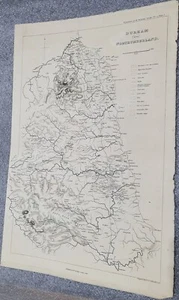
Carte géologique « Durham and Northumberland », 1816

EUR 60.00
ApproximatelyRM 294.40
or Best Offer
Condition:
“Provenant du fonds documentaire personnel de Brochant de Villiers (1772-1840).”
Oops! Looks like we're having trouble connecting to our server.
Refresh your browser window to try again.
Shipping:
EUR 30.00 (approx RM 147.20) Colissimo International.
Located in: Cournon d'Auvergne, France
Delivery:
Estimated between Thu, 23 Oct and Mon, 3 Nov to 94104
Returns:
30 days return. Buyer pays for return shipping. If you use an eBay shipping label, it will be deducted from your refund amount.
Coverage:
Read item description or contact seller for details. See all detailsSee all details on coverage
(Not eligible for eBay purchase protection programmes)
Seller assumes all responsibility for this listing.
eBay item number:365262455172
Item specifics
- Seller Notes
- “Provenant du fonds documentaire personnel de Brochant de Villiers (1772-1840).”
- Epoque
- XIXème et avant
- Pays de fabrication
- France
- Editeur
- Published by W. Phillips London 1816
- Lieu
- Durham, Northumberland, Angleterre
- Thème
- Géologie, Minéralogie, Durham, Northumberland
Item description from the seller

Seller feedback (1,077)
- u***6 (557)- Feedback left by buyer.Past monthVerified purchaseParfait
- 5***m (69)- Feedback left by buyer.Past monthVerified purchaseExpédition très rapide, échantillon soigneusement emballé et correspondant à la description +++++++++
- l***o (288)- Feedback left by buyer.Past monthVerified purchaseSuper transaction, comme d'hab. Merci pour le petit geste commercial