Picture 1 of 5


Gallery
Picture 1 of 5


Have one to sell?
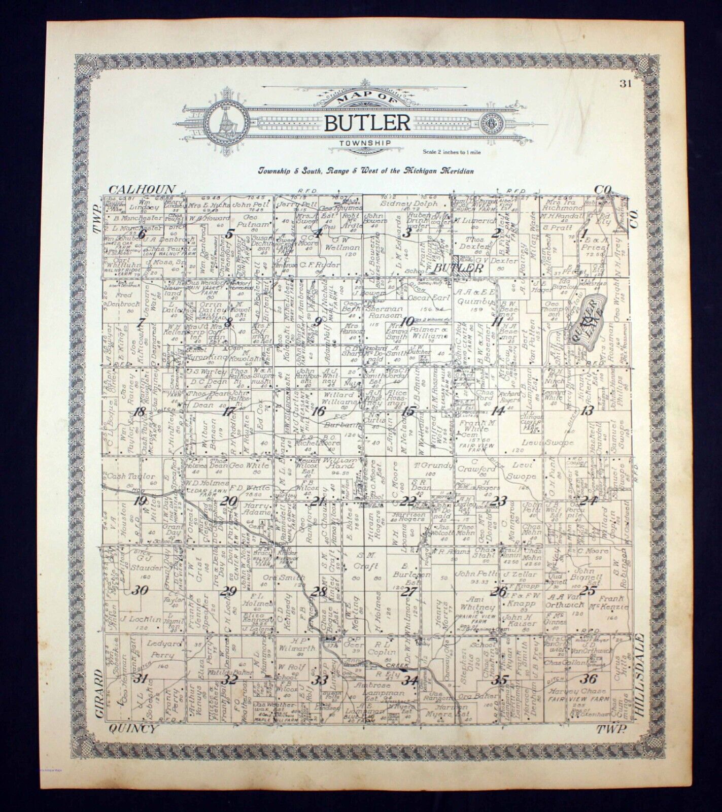
1915 Plat Map Butler Township Branch County Michigan Quaker Lake

US $17.50
ApproximatelyRM 74.04
or Best Offer
Condition:
“Good condition (see photos).”
Oops! Looks like we're having trouble connecting to our server.
Refresh your browser window to try again.
Shipping:
US $8.75 (approx RM 37.02) USPS Ground Advantage®.
Located in: Corunna, Michigan, United States
Delivery:
Estimated between Fri, 1 Aug and Thu, 7 Aug to 94104
Returns:
30 days return. Seller pays for return shipping.
Coverage:
Read item description or contact seller for details. See all detailsSee all details on coverage
(Not eligible for eBay purchase protection programmes)
Seller assumes all responsibility for this listing.
eBay item number:365089749082
Item specifics
- Seller Notes
- “Good condition (see photos).”
- Date Range
- 1910-1919
- Type
- Plat Map
- Format
- Atlas
- US State
- Michigan
- Printing Technique
- Engraving
- Year
- 1915
- Original/Reproduction
- Antique Original
- Cartographer/Publisher
- Geo. A. Ogle & Co.
- Country/Region
- United States of America
Item description from the seller

Seller feedback (10,131)
- m***e (304)- Feedback left by buyer.Past monthVerified purchaseGreat
- -***l (4264)- Feedback left by buyer.Past monthVerified purchaseWell packed, fast shipping and smooth overall transaction. Thanks again
- 4***d- Feedback left by buyer.Past monthVerified purchaseA wonderful item in fantastic condition, packed very carefully and shipped rapidly, thank you for a fine transaction.
More to explore :
- Michigan Antique North America County Maps,
- Michigan County Map Antique North America Atlas Maps,
- Michigan Lithography Antique North America County Maps,
- Michigan Antique Original Antique North America County Maps,
- Michigan Vintage Original Antique North America County Maps,
- Antique County Maps,
- Michigan 1400-1499 Date Range Antique North America County Maps,
- County Map Antique Africa Atlas Maps,
- County Map Antique Asia Atlas Maps,
- County Map Antique World Folding Maps
Seller feedback (10,131)
- m***e (304)- Feedback left by buyer.Past monthVerified purchaseGreat
- -***l (4264)- Feedback left by buyer.Past monthVerified purchaseWell packed, fast shipping and smooth overall transaction. Thanks again
- 4***d- Feedback left by buyer.Past monthVerified purchaseA wonderful item in fantastic condition, packed very carefully and shipped rapidly, thank you for a fine transaction.