Picture 1 of 3


Gallery
Picture 1 of 3


Have one to sell?
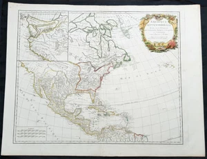
1783 R. De Vaugondy Large Antique 1st Post Revolutionary Map of North America

US $950.00
ApproximatelyRM 4,011.85
or Best Offer
Condition:
“Fine”
Oops! Looks like we're having trouble connecting to our server.
Refresh your browser window to try again.
Shipping:
US $49.99 (approx RM 211.11) Expedited Shipping from outside US.
Located in: Ivanhoe, VIC, Australia
Delivery:
Estimated between Fri, 17 Oct and Wed, 29 Oct to 94104
Returns:
30 days return. Seller pays for return shipping.
Coverage:
Read item description or contact seller for details. See all detailsSee all details on coverage
(Not eligible for eBay purchase protection programmes)
Seller assumes all responsibility for this listing.
eBay item number:354340680387
Item specifics
- Seller Notes
- “Fine”
- Date Range
- 1700-1799
- Type
- World Atlas
- US State
- North America
- Format
- Atlas Map
- Printing Technique
- Copper Plate
- Year
- 1783
- Original/Reproduction
- Antique Original
- Cartographer/Publisher
- De Vaugondy
- Country/Region
- United States of America
Item description from the seller
Seller business information
VAT number: AU 54097057022

Seller feedback (6,622)
- eBay automated feedback- Feedback left by buyer.Past monthOrder delivered on time with no issues
- eBay automated feedback- Feedback left by buyer.Past monthOrder delivered on time with no issues
- a***d (1048)- Feedback left by buyer.Past monthVerified purchaseGorgeous print
More to explore :
- Antique North America Maps & Atlases,
- Antique North America Michigan Maps,
- Antique North America Topographical Maps,
- Antique North America Wall Maps,
- Antique North America Railroad Maps,
- Antique North America Geological Maps,
- Antique North America Political Maps,
- North Carolina Antique North America Maps & Atlases,
- Antique North America City Maps,
- Arkansas Antique North America Maps & Atlases
Seller feedback (6,622)
- eBay automated feedback- Feedback left by buyer.Past monthOrder delivered on time with no issues
- eBay automated feedback- Feedback left by buyer.Past monthOrder delivered on time with no issues
- a***d (1048)- Feedback left by buyer.Past monthVerified purchaseGorgeous print