Picture 1 of 4


Gallery
Picture 1 of 4


Have one to sell?
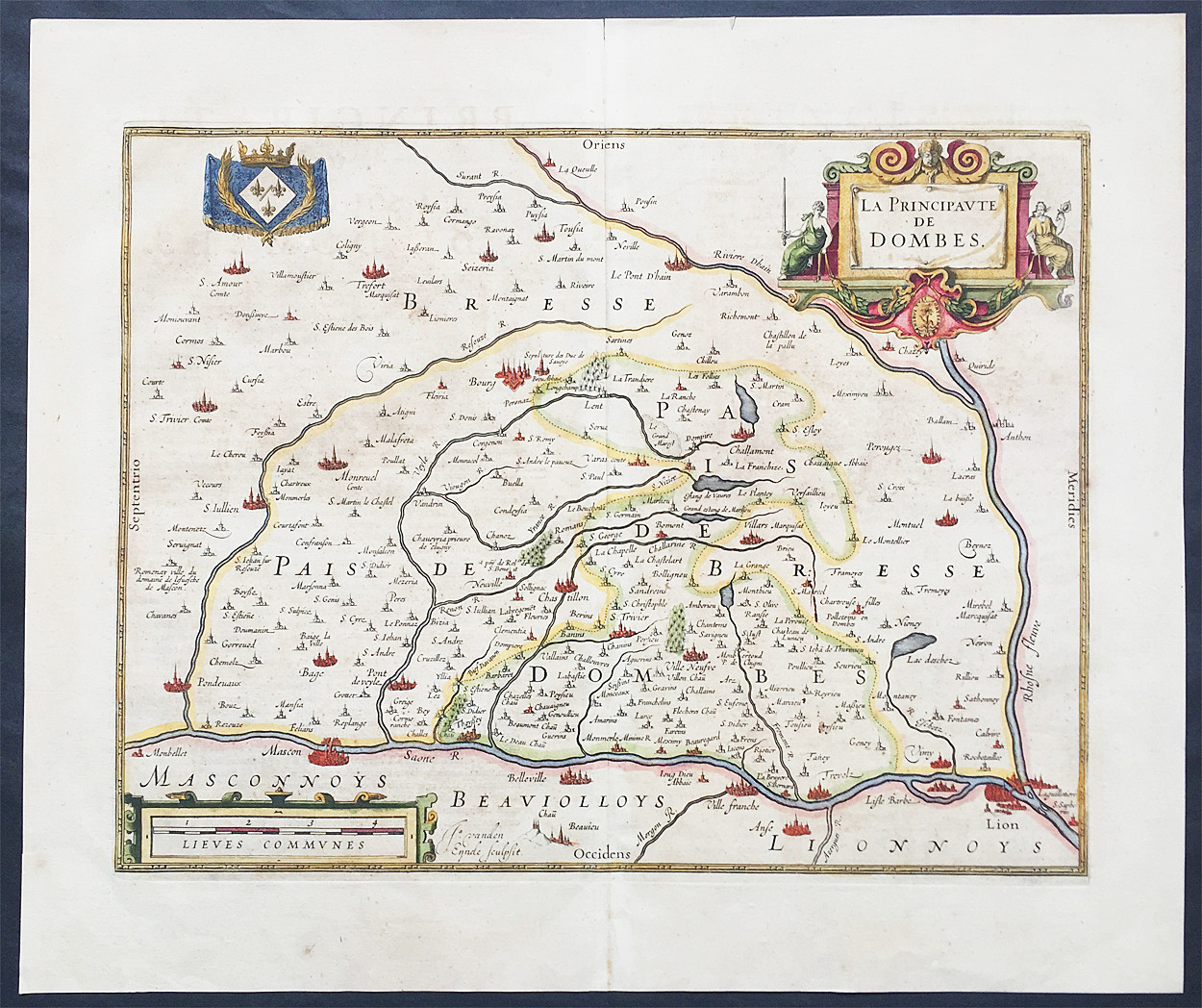
1638 Henricus Hondius Antique Map of the Principality of Dombes, Ain, SE France

US $250.00
ApproximatelyRM 1,057.20
Condition:
Oops! Looks like we're having trouble connecting to our server.
Refresh your browser window to try again.
Shipping:
US $14.99 (approx RM 63.39) Standard Shipping from outside US.
Located in: Ivanhoe, VIC, Australia
Delivery:
Estimated between Mon, 27 Oct and Wed, 5 Nov
Returns:
30 days return. Seller pays for return shipping.
Coverage:
Read item description or contact seller for details. See all detailsSee all details on coverage
(Not eligible for eBay purchase protection programmes)
Seller assumes all responsibility for this listing.
eBay item number:354324187432
Item specifics
- Date Range
- 1600-1699
- Type
- County Map
- Printing Technique
- Copper Plate
- Format
- Atlas Map
- Year
- 1638
- Original/Reproduction
- Antique Original
- Cartographer/Publisher
- Hondius
- City
- Lyon
- Country/Region
- France
Item description from the seller
Seller business information
VAT number: AU 54097057022

Seller feedback (6,625)
- 0***t (162)- Feedback left by buyer.Past 6 monthsVerified purchaseA fine looking leaf in great condition. Looking forward to getting deeper into the historical events depicted in this leaf, there is a lot there!. My local postmistress was keen to see this leaf (she has seen quite a few of my leaf purchases over the years) and spent some time examining the woodcut. (thankfully there were no customers waiting). Postage very reasonable. Very well packed. Exactly as described. Very good value and a great seller.1598 Seb. Munster Antique Print of the Council of Basel in 1455, Pope Martin V (#354324211824)
- t***h (1164)- Feedback left by buyer.Past yearVerified purchaseExcellent eBay seller. Experienced a Postal strike here in Canada, seller kept item until strike was over and checked regularly with their Postal service, Australia Post for updates. Item shipped promptly after strike was over. Good communication, item well packaged, and reasonable shipping costs. Thank you very much.1778 Zatta Original Antique Map Nova Scotia, St Lawrence River, Ontario, Canada (#374298612816)
- d***z (102)- Feedback left by buyer.Past 6 monthsVerified purchaseGreat seller! Item as described, well packaged and arrived quickly. Very happy - thank you :)
More to explore :
- Henry Hondius Antique Atlas Maps,
- Henry Hondius Antique County Maps,
- Antique European Maps & Atlases Henry Hondius,
- Henry Hondius Antique Maps, Atlases & Globes,
- Henry Hondius Antique Europe Atlas Maps,
- Antique European Maps & Atlases Jodocus Hondius,
- Henry Hondius Copper Plate Antique Maps, Atlases & Globes,
- France Antique Europe Topographical Maps,
- France Antique Europe River Maps,
- France Antique Europe Folding Maps
Seller feedback (6,625)
- 0***t (162)- Feedback left by buyer.Past 6 monthsVerified purchaseA fine looking leaf in great condition. Looking forward to getting deeper into the historical events depicted in this leaf, there is a lot there!. My local postmistress was keen to see this leaf (she has seen quite a few of my leaf purchases over the years) and spent some time examining the woodcut. (thankfully there were no customers waiting). Postage very reasonable. Very well packed. Exactly as described. Very good value and a great seller.1598 Seb. Munster Antique Print of the Council of Basel in 1455, Pope Martin V (#354324211824)
- t***h (1164)- Feedback left by buyer.Past yearVerified purchaseExcellent eBay seller. Experienced a Postal strike here in Canada, seller kept item until strike was over and checked regularly with their Postal service, Australia Post for updates. Item shipped promptly after strike was over. Good communication, item well packaged, and reasonable shipping costs. Thank you very much.1778 Zatta Original Antique Map Nova Scotia, St Lawrence River, Ontario, Canada (#374298612816)
- d***z (102)- Feedback left by buyer.Past 6 monthsVerified purchaseGreat seller! Item as described, well packaged and arrived quickly. Very happy - thank you :)