Picture 1 of 2

Gallery
Picture 1 of 2


Have one to sell?
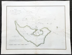
1827 Dumont D Urville Large Antique Map The Island of Tongatapu Tonga, Astrolabe

US $375.00
ApproximatelyRM 1,583.63
or Best Offer
Condition:
“VG”
Oops! Looks like we're having trouble connecting to our server.
Refresh your browser window to try again.
Shipping:
US $14.99 (approx RM 63.30) Standard Shipping from outside US.
Located in: Ivanhoe, VIC, Australia
Delivery:
Estimated between Wed, 22 Oct and Fri, 31 Oct to 94104
Returns:
30 days return. Seller pays for return shipping.
Coverage:
Read item description or contact seller for details. See all detailsSee all details on coverage
(Not eligible for eBay purchase protection programmes)
Seller assumes all responsibility for this listing.
eBay item number:354324182587
Item specifics
- Seller Notes
- “VG”
- Date Range
- 1800-1899
- Type
- World Atlas
- Format
- Atlas Map
- Printing Technique
- Lithography
- Year
- 1827
- Original/Reproduction
- Antique Original
- Cartographer/Publisher
- D Urville
- Country/Region
- Tonga
Item description from the seller
Seller business information
VAT number: AU 54097057022

Seller feedback (6,624)
- Automatische Bewertung von eBay- Feedback left by buyer.Past monthBestellung pünktlich und problemlos geliefert
- Automatische Bewertung von eBay- Feedback left by buyer.Past monthBestellung pünktlich und problemlos geliefert
- Automatische Bewertung von eBay- Feedback left by buyer.Past monthBestellung pünktlich und problemlos geliefert
More to explore :
- Tonga Antique Australia/Oceania Maps & Atlases,
- Rhode Island County Map Antique North America Atlas Maps,
- Antique South American Maps & Atlases Falkland Islands,
- Rhode Island Antique North America Nautical Maps,
- Rhode Island Antique North America Folding Maps,
- Rhode Island Antique North America City Maps,
- Mariner's Astrolabe Antique Maritime Navigational Instruments,
- Virgin Islands Antique Central American/Caribbean Maps & Atlases,
- Providence Rhode Island Antique Original Antique North American Maps & Atlases,
- Lithography Rhode Island Antique North America Atlas Maps
Seller feedback (6,624)
- Automatische Bewertung von eBay- Feedback left by buyer.Past monthBestellung pünktlich und problemlos geliefert
- Automatische Bewertung von eBay- Feedback left by buyer.Past monthBestellung pünktlich und problemlos geliefert
- Automatische Bewertung von eBay- Feedback left by buyer.Past monthBestellung pünktlich und problemlos geliefert