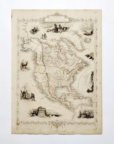
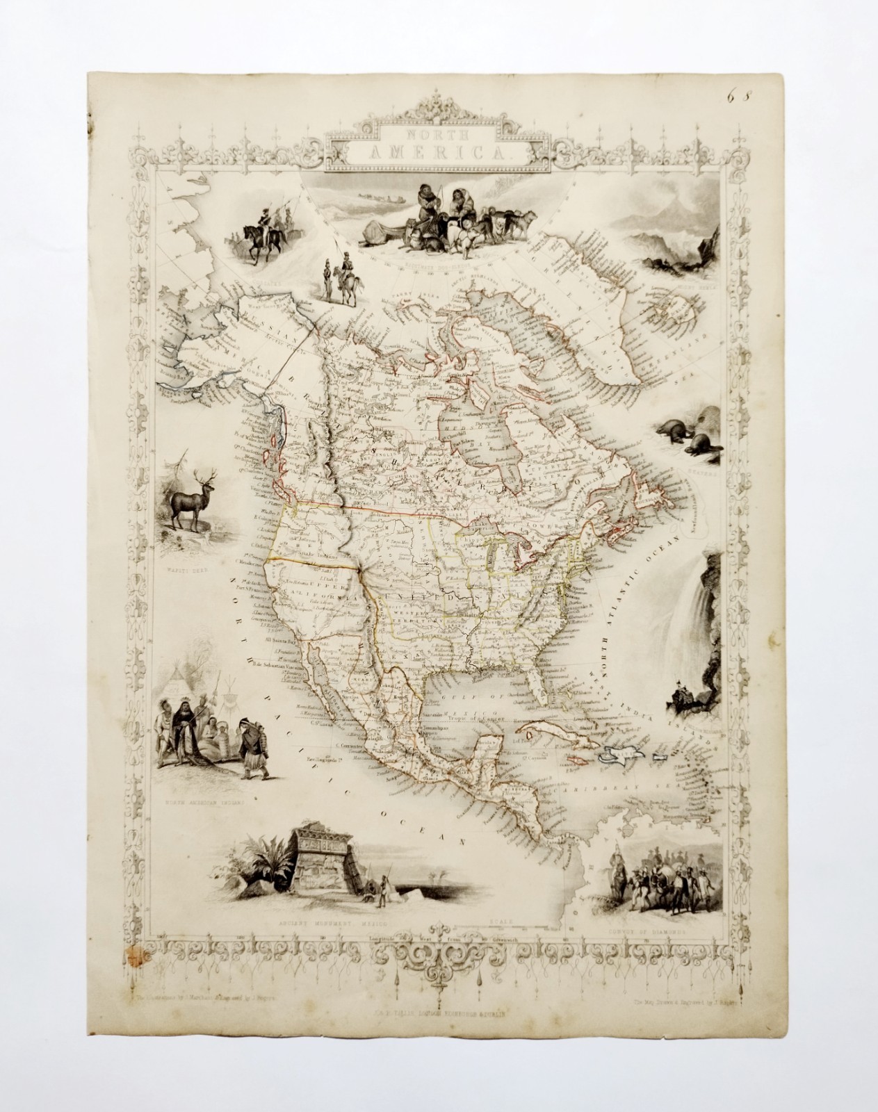
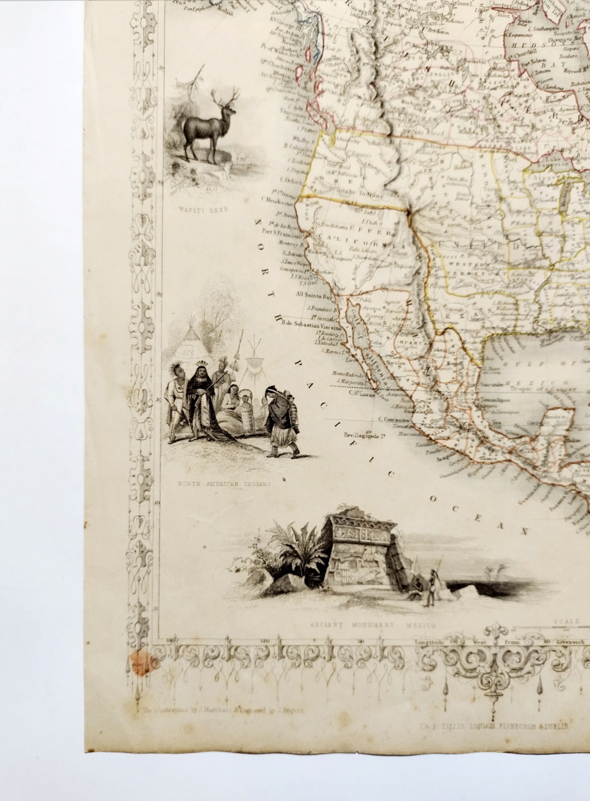
NORTH AMERICA USA CANADA original antique hand-coloured map Tallis & Rapkin 1850
GBP 75.00GBP 75.00
Jul 31, 06:13Jul 31, 06:13
Picture 1 of 5


Gallery
Picture 1 of 5


Have one to sell?
NORTH AMERICA USA CANADA original antique hand-coloured map Tallis & Rapkin 1850
Condition:
“Please read the item description & refer to the scans”
Ended: Jul 31, 2025 06:13:09 MYT
Oops! Looks like we're having trouble connecting to our server.
Refresh your browser window to try again.
Shipping:
GBP 22.40 (approx RM 127.93) Royal Mail International Signed.
Located in: Hampshire, United Kingdom
Delivery:
Estimated between Fri, 15 Aug and Fri, 22 Aug
Returns:
14 days return. Buyer pays for return shipping. If you use an eBay shipping label, it will be deducted from your refund amount.
Coverage:
Read item description or contact seller for details. See all detailsSee all details on coverage
(Not eligible for eBay purchase protection programmes)
Shop with confidence
Seller assumes all responsibility for this listing.
eBay item number:336093892142
Item specifics
- Seller Notes
- “Please read the item description & refer to the scans”
- Antique
- Yes
- US State
- California
- Printing Technique
- hand-coloured engraving
- Cartographer/Publisher
- John Tallis, John Rapkin
- City
- New York
- Subject
- NORTH AMERICA USA CANADA original antique map Tallis Rapkin 1850
- Date Range
- 1800-1899
- Type
- NORTH AMERICA USA CANADA original antique map Tallis Rapkin 1850
- Format
- Sheet Map
- Mexican State
- Aguascalientes, Baja California, Baja California Sur, Campeche, Chiapas, Chihuahua, Coahuila, Colima, Durango, Guanajuato, Guerrero, Hidalgo, Jalisco, Morelos, Nayarit, Nuevo León, Oaxaca, Puebla, Querétaro, Quintana Roo, San Luis Potosí, Sinaloa, Sonora, Tabasco, Tamaulipas, Tlaxcala, Veracruz, Yucatán, Zacatecas
- Year
- 1850
- Canadian Province
- Alberta, British Columbia, Manitoba, New Brunswick, Newfoundland & Labrador, Northwest Territories, Nova Scotia, Nunavut, Ontario, Prince Edward Island, Quebec, Saskatchewan, Yukon
- Era
- 1800s
- Original/Reproduction
- Antique Original
- Country/Region
- Arctic Circle, Canada, Greenland, Mexico, North America, United States of America
Item description from the seller
Seller feedback (1,718)
- eBay automated feedback- Feedback left by buyer.Past monthOrder completed successfully—tracked and on time
- 4***7 (0)- Feedback left by buyer.Past monthVerified purchaseGood eBayer. Postage fine and packaging v good.
- eBay automated feedback- Feedback left by buyer.Past monthOrder completed successfully—tracked and on time
More to explore :
- Canada Antique Original Antique North America Maps & Atlases,
- Canada Antique Original Antique North America Railroad Maps,
- Canada Vintage Original Antique North America Maps & Atlases,
- Canada Antique North America Topographical Maps,
- Canada Antique North America Wall Maps,
- Alberta Canada Antique North America Maps & Atlases,
- Antique Original Antique North America Maps & Atlases,
- Vancouver Canada Antique North America Maps & Atlases,
- Montreal Canada Antique North America Maps & Atlases,
- Ontario Canada Antique North America Topographical Maps