
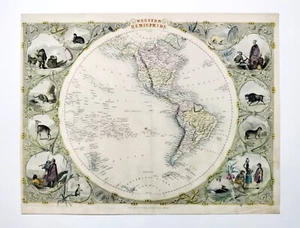
Western Hemisphere North & South America original antique map Tallis 1851 superb
GBP 50.00GBP 50.00
Jul 31, 05:54Jul 31, 05:54
Picture 1 of 6


Gallery
Picture 1 of 6


Have one to sell?
Western Hemisphere North & South America original antique map Tallis 1851 superb
Condition:
“Please read the item description & refer to the scans”
Ended: Jul 31, 2025 05:54:27 MYT
Oops! Looks like we're having trouble connecting to our server.
Refresh your browser window to try again.
Shipping:
GBP 22.40 (approx RM 126.63) Royal Mail International Signed.
Located in: Hampshire, United Kingdom
Delivery:
Estimated between Tue, 5 Aug and Wed, 13 Aug to 94104
Returns:
14 days return. Buyer pays for return shipping. If you use an eBay shipping label, it will be deducted from your refund amount.
Coverage:
Read item description or contact seller for details. See all detailsSee all details on coverage
(Not eligible for eBay purchase protection programmes)
Shop with confidence
Seller assumes all responsibility for this listing.
eBay item number:336093876712
Item specifics
- Seller Notes
- “Please read the item description & refer to the scans”
- Antique
- Yes
- US State
- California
- Printing Technique
- hand-coloured engraving
- Subject 3
- North & South America antique Victorian map Tallis Rapkin 1851
- Subject 2
- Western Hemisphere North South America map Tallis Rapkin 1851
- Cartographer/Publisher
- John Tallis, John Rapkin
- City
- New York
- Subject
- Western Hemisphere North & South America antique map Tallis 1851
- Date Range
- 1800-1899
- Type
- Western Hemisphere North South America original antique map 1851
- Format
- Sheet Map
- Mexican State
- Aguascalientes, Baja California, Baja California Sur, Campeche, Chiapas, Chihuahua, Colima, Durango, Guanajuato, Guerrero, Hidalgo, Jalisco, Michoacán, Morelos, Nuevo León, Oaxaca, Puebla, Querétaro, Quintana Roo, San Luis Potosí, Sinaloa, Sonora, Tabasco, Tamaulipas, Tlaxcala, Veracruz, Yucatán, Zacatecas
- Year
- 1851
- Canadian Province
- Alberta, British Columbia, Manitoba, New Brunswick, Newfoundland & Labrador, Northwest Territories, Nova Scotia, Nunavut, Ontario, Prince Edward Island, Quebec, Saskatchewan, Yukon
- Era
- 1800s
- Original/Reproduction
- Antique Original
- Country/Region
- Arctic Circle, Canada, Greenland, Mexico, North America, United States of America
Item description from the seller
Seller feedback (1,701)
- eBay automated Feedback- Feedback left by buyer.Past monthOrder completed successfully – tracked and on time
- eBay automated Feedback- Feedback left by buyer.Past monthOrder completed successfully – tracked and on time
- eBay automated Feedback- Feedback left by buyer.Past monthOrder completed successfully – tracked and on time
More to explore :
- Western Hemisphere Antique Original Antique World Maps & Atlases,
- Western Hemisphere Antique Original Antique World Sheet Maps,
- South Carolina Antique Original Antique North America Railroad Maps,
- South Carolina Antique Original Antique North America County Maps,
- South Carolina Antique Original Antique North America Folding Maps,
- South Dakota Antique Original Antique North America Geological Maps,
- South Carolina Antique North America Maps & Atlases,
- Antique Original Antique South America School Maps,
- Antique Original Antique South America Sheet Maps,
- Western Hemisphere Physical Map Antique World Sheet Maps