Picture 1 of 6


Gallery
Picture 1 of 6


Have one to sell?
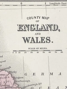
American State map from Mitchell's Atlas 1865 England and Wales Dated 1860
US $38.00
ApproximatelyRM 160.73
or Best Offer
Condition:
Oops! Looks like we're having trouble connecting to our server.
Refresh your browser window to try again.
Shipping:
US $8.80 (approx RM 37.22) USPS Ground Advantage®.
Located in: Folsom, California, United States
Delivery:
Estimated between Mon, 27 Oct and Wed, 29 Oct to 94104
Returns:
30 days return. Seller pays for return shipping.
Coverage:
Read item description or contact seller for details. See all detailsSee all details on coverage
(Not eligible for eBay purchase protection programmes)
Seller assumes all responsibility for this listing.
eBay item number:335924262998
Item specifics
- Date Range
- 1800-1899
- Format
- Atlas
- Year
- 1865
- Original/Reproduction
- Vintage Original
- Country/Region
- England
Item description from the seller
Seller feedback (1,724)
- b***i (7)- Feedback left by buyer.Past monthVerified purchaseWas exactly as described. It was packaged with care and in a way that the photo could not be bent or damaged. Communication was clear and shipped in a timely fashion. 10/10 to the seller!
- n***n (445)- Feedback left by buyer.Past 6 monthsVerified purchaseMy order arrived so quickly I was completely surprised with a wonderful service the great packaging the value of what I paid for, and that the patches were described exactly as they arrived in the mailVintage 1950s Lot of 11 Shooting Patches NRA Club Hunter Safety Pistol Shoots (#335980893384)
- h***h (216)- Feedback left by buyer.Past 6 monthsVerified purchaseItem was well described with plenty of good quality, in focus images. Price was good and delivery was fast. The item arrived securely packaged. I have no hesitation in recommending this seller. Thank you.Vintage Inuit Soap-Stone Frog Carving, Northwest Item… (#335985449144)
More to explore :
- Wales 1800-1899 Date Range Antique Europe Atlas Maps,
- Wales Antique Europe Atlas Maps,
- England 1700-1799 Date Range Antique Europe Atlas Maps,
- England 1800-1899 Date Range Antique Europe Atlas Maps,
- Wales Lithography Antique Europe Atlas Maps,
- Wales Copper Plate Antique Europe Atlas Maps,
- Atlas 1910-1919 Date Range County Map Antique North American Maps & Atlases,
- Wales 1800-1899 Date Range Antique Europe Sheet Maps,
- Antique European Maps & Atlases Wales 1600-1699 Date Range,
- Wales 1700-1799 Date Range Antique Europe County Maps