Picture 1 of 6


Gallery
Picture 1 of 6


Have one to sell?
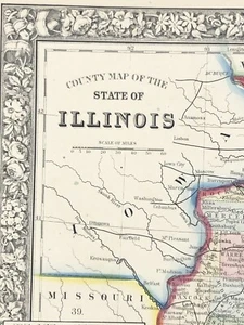
American State map from Mitchell's Atlas 1865 Illinois, Chicago Dated 1861
US $45.00
ApproximatelyRM 190.94
or Best Offer
Condition:
Oops! Looks like we're having trouble connecting to our server.
Refresh your browser window to try again.
Shipping:
US $8.80 (approx RM 37.34) USPS Ground Advantage®.
Located in: Folsom, California, United States
Delivery:
Estimated between Thu, 24 Jul and Mon, 28 Jul to 94104
Returns:
30 days return. Seller pays for return shipping.
Coverage:
Read item description or contact seller for details. See all detailsSee all details on coverage
(Not eligible for eBay purchase protection programmes)
Seller assumes all responsibility for this listing.
eBay item number:335922372860
Item specifics
- Date Range
- 1800-1899
- US State
- Illinois
- Format
- Atlas
- Year
- 1865
- Original/Reproduction
- Vintage Original
- City
- Chicago
Item description from the seller
Seller feedback (1,671)
- c***5 (1278)- Feedback left by buyer.Past monthVerified purchaseGreat
- b***- (1935)- Feedback left by buyer.Past monthVerified purchaseNice packing job and fast turnaround on order. Great piece.
- a***b (8001)- Feedback left by buyer.Past monthVerified purchaseFast delivery, smooth transaction. highly recommended seller
More to explore :
- Chicago Illinois Antique North America Atlas Maps,
- Illinois Antique North American Maps Atlas 1800-1899 Date Range & Atlases,
- Chicago Illinois Antique North American Maps & Atlases 1900-1909 Date Range,
- Chicago Illinois Antique North American Maps & Atlases,
- Chicago Copper Plate Illinois American Antique Maps & Atlases,
- Atlas 1900-1909 Date Range County Map Antique North American Maps & Atlases,
- Atlas 1920-1929 Date Range County Map Antique North American Maps & Atlases,
- Atlas 1930-1939 Date Range County Map Antique North American Maps & Atlases,
- Illinois Lithography Antique North America Atlas Maps,
- Antique World Atlas 1920-1929 Date Range Maps, Atlases & Globes Atlas Map