Picture 1 of 7


Gallery
Picture 1 of 7


Have one to sell?
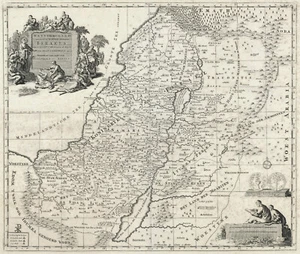
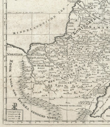
Map "Het Heylige Land verdeeld in de Twaalf Stammen Israels" (Holy Land) c. 1700
GBP 200.00
ApproximatelyRM 1,141.93
or Best Offer
Condition:
Oops! Looks like we're having trouble connecting to our server.
Refresh your browser window to try again.
Shipping:
GBP 18.00 (approx RM 102.77) Royal Mail International Tracked.
Located in: London, United Kingdom
Delivery:
Estimated between Fri, 19 Sep and Wed, 1 Oct to 94104
Returns:
No returns accepted.
Coverage:
Read item description or contact seller for details. See all detailsSee all details on coverage
(Not eligible for eBay purchase protection programmes)
Seller assumes all responsibility for this listing.
eBay item number:335570591707
Item specifics
- Date Range
- 1700-1799
- Antique
- Yes
- Type
- Physical Map
- Format
- Sheet Map
- Printing Technique
- Copper Plate
- Year
- 1700
- Era
- 1700s
- Original/Reproduction
- Antique Original
- Cartographer/Publisher
- Covens & Mortier
- Country/Region
- Israel, Jordan, Lebanon, Palestine, Syria
Item description from the seller
Popular categories from this store
Seller feedback (315)
- eBay automated feedback- Feedback left by buyer.Past monthOrder completed successfully—tracked and on time
- 3***l (186)- Feedback left by buyer.Past monthVerified purchaseI am very sorry that this picture has been confiscated by Chinese customs because it conflicts with Chinese customs policies.
- 3***l (186)- Feedback left by buyer.Past monthVerified purchaseI am very sorry that this picture has been confiscated by Chinese customs because it conflicts with Chinese customs policies.
More to explore :
- Antique Asian Maps & Atlases Israel 1700-1799 Date Range,
- Israel Antique Asia Atlas Maps,
- Israel Antique Asia Folding Maps,
- Israel Antique Asia City Maps,
- Antique Asian Maps & Atlases Israel,
- Guillaume De L'Isle 1700-1799 Date Range Antique Maps, Atlases & Globes,
- Guillaume De L'Isle 1700-1799 Date Range Antique Europe Maps & Atlases,
- 1700-1799 Antique World Atlas Maps,
- 1700-1799 Date Range Antique City Maps,
- 1700-1799 Date Range Antique Wall Maps