Picture 1 of 11


Gallery
Picture 1 of 11


Have one to sell?
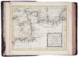
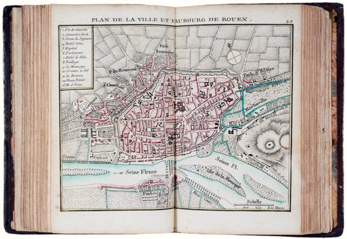
Antique "Atlas Maritime de toutes les Côtes de France" Rigobert Bonne, 1778

GBP 2,700.00
ApproximatelyRM 15,376.90
or Best Offer
Condition:
Oops! Looks like we're having trouble connecting to our server.
Refresh your browser window to try again.
Shipping:
GBP 18.00 (approx RM 102.51) Royal Mail International Tracked.
Located in: London, United Kingdom
Delivery:
Estimated between Sat, 9 Aug and Thu, 14 Aug to 94104
Returns:
No returns accepted.
Coverage:
Read item description or contact seller for details. See all detailsSee all details on coverage
(Not eligible for eBay purchase protection programmes)
Seller assumes all responsibility for this listing.
eBay item number:335558185376
Item specifics
- Format
- Atlas
- Era
- 1700s
- Printing Technique
- Copper Plate
- Year
- 1778
- Country/Region
- France
- Cartographer/Publisher
- Rigobert Bonne - Lattré
- Antique
- Yes
- Date Range
- 1700-1799
- Type
- Road Atlas
- Original/Reproduction
- Antique Original
Item description from the seller

Popular categories from this store
Seller feedback (303)
- eBay automated Feedback- Feedback left by buyer.Past monthOrder completed successfully – tracked and on time
- eBay automated Feedback- Feedback left by buyer.Past monthOrder completed successfully – tracked and on time
- eBay automated Feedback- Feedback left by buyer.Past monthOrder completed successfully – tracked and on time
More to explore :
- France Maritime Antiques,
- France Antique Maritime Compasses,
- France Antique Maritime Telescopes,
- France Antique Maritime Clocks,
- France Antique Original Maritime Antiques,
- France Antique Original Antique Maritime Compasses,
- Maritime Antiques,
- Antique Maritime Clocks,
- Antique Maritime Chronometers,
- Antique Blanc De Chine Figurines & Statues
Popular categories from this store
Seller feedback (303)
- eBay automated Feedback- Feedback left by buyer.Past monthOrder completed successfully – tracked and on time
- eBay automated Feedback- Feedback left by buyer.Past monthOrder completed successfully – tracked and on time
- eBay automated Feedback- Feedback left by buyer.Past monthOrder completed successfully – tracked and on time