Picture 1 of 1
Gallery
Picture 1 of 1

Have one to sell?
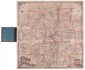
Driving Road Chart of the City of Hartford and Vicinity. 1884.
US $1,800.00
ApproximatelyRM 7,576.20
or Best Offer
Condition:
Oops! Looks like we're having trouble connecting to our server.
Refresh your browser window to try again.
Shipping:
US $35.00 (approx RM 147.32) FedEx Ground / FedEx Home Delivery®.
Located in: Bath, Maine, United States
Delivery:
Estimated between Wed, 8 Oct and Sat, 11 Oct to 94104
Returns:
30 days return. Buyer pays for return shipping. If you use an eBay shipping label, it will be deducted from your refund amount.
Coverage:
Read item description or contact seller for details. See all detailsSee all details on coverage
(Not eligible for eBay purchase protection programmes)
Seller assumes all responsibility for this listing.
eBay item number:334904041348
Item specifics
- Signed
- No
Item description from the seller
Popular categories from this store
Seller feedback (420)
- k***k (1317)- Feedback left by buyer.Past monthVerified purchaseFast shipping and very satisfied. Thanks!
- Évaluations automatiques eBay- Feedback left by buyer.Past monthCommande livrée dans les délais et sans problème
- Évaluations automatiques eBay- Feedback left by buyer.Past monthCommande livrée dans les délais et sans problème
More to explore :
- Antique Maritime Navigational Charts,
- WWII Antique Maritime Navigational Charts,
- Australia Antique Maritime Navigational Charts,
- WWI Antique Maritime Navigational Charts,
- Canada Antique Maritime Navigational Charts,
- United States Antique Maritime Navigational Charts,
- United States WWII Antique Maritime Navigational Charts,
- United States WWI Antique Maritime Navigational Charts,
- US Coast Guard Antique Maritime Navigational Charts,
- US Navy Antique Original Antique Maritime Navigational Charts