Picture 1 of 4


Gallery
Picture 1 of 4


Have one to sell?
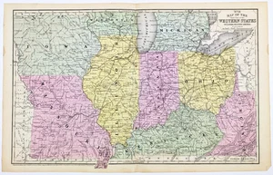
1852 OHIO - MICHIGAN - KENTUCKY - ILLINOIS - INDIANA - MISSOURI Map ORIGINAL

US $44.00
ApproximatelyRM 181.82
or Best Offer
Condition:
“GOOD CONDITION, DISCOLORATION, CENTER CREASE”
Oops! Looks like we're having trouble connecting to our server.
Refresh your browser window to try again.
Shipping:
Free USPS Ground Advantage®.
Located in: Carefree, Arizona, United States
Delivery:
Estimated between Mon, 1 Dec and Sat, 6 Dec to 94104
Ships today if you order in the next 4 hrs 52 mins
Returns:
30 days return. Seller pays for return shipping.
Coverage:
Read item description or contact seller for details. See all detailsSee all details on coverage
(Not eligible for eBay purchase protection programmes)
About this item
Seller assumes all responsibility for this listing.
eBay item number:326871729823
Item specifics
- Seller Notes
- “GOOD CONDITION, DISCOLORATION, CENTER CREASE”
- Country of Origin
- United States
- Date Range
- 1800-1899
- Type
- County Map
- Format
- Atlas Map
- Printing Technique
- Copper Plate
- US State
- Illinois, Indiana, Kentucky, Michigan, Missouri, Ohio, Virginia, West Virginia
- Year
- 1852
- Original/Reproduction
- Antique Original
- Cartographer/Publisher
- Samuel Augustus Mitchell
- City
- Cincinnati
- Country/Region
- United States of America
Item description from the seller

Seller feedback (6,733)
- n***n (147)- Feedback left by buyer.Past 6 monthsVerified purchaseI was excited to find the lithograph of Mrs. Ann (Taylor) Reeve, the aunt of my 4th great grandmother. Thank you SELSA84 for making these beautiful pictures available. It was shipped immediately In a couple of days was able to open a well secured cylinder package with the picture inside, 10x better then described and pictured online. Priced very reasonably, but priceless to me. Thank you.
- 3***3 (857)- Feedback left by buyer.Past 6 monthsVerified purchaseThe map is exactly as described, fast mailing by seller, Great Communications and over the top packaging. A+++++ eBayer Thank you The USPS Not so much
- _***c (140)- Feedback left by buyer.Past 6 monthsVerified purchaseGreat Ebay Seller! My antique map of Colorado arrived in perfect condition ~ Item was as described ~ Item was packaged well ~ Seller combined shipping cost of 4 historical maps purchased ~ Great Value ~ Transaction deserves 5 STARS! Again, thank you.1885 MAP COLORADO - Original (12x9) GEORGE CRAM - Townships Railroads (#226803088841)
More to explore :
- Missouri Antique Original Antique North America Maps & Atlases,
- Missouri Vintage Original Antique North America Topographical Maps,
- Missouri Antique Original Antique North America County Maps,
- Missouri Vintage Original Antique North America Folding Maps,
- Missouri Antique Original Antique North America River Maps,
- Illinois Antique Original Antique North America County Maps,
- Illinois Antique Original Antique North America Folding Maps,
- Kentucky Antique Original Antique North America River Maps,
- Illinois Vintage Original Antique North America City Maps,
- Ohio Antique Original Antique North America City Maps
Seller feedback (6,733)
- n***n (147)- Feedback left by buyer.Past 6 monthsVerified purchaseI was excited to find the lithograph of Mrs. Ann (Taylor) Reeve, the aunt of my 4th great grandmother. Thank you SELSA84 for making these beautiful pictures available. It was shipped immediately In a couple of days was able to open a well secured cylinder package with the picture inside, 10x better then described and pictured online. Priced very reasonably, but priceless to me. Thank you.
- 3***3 (857)- Feedback left by buyer.Past 6 monthsVerified purchaseThe map is exactly as described, fast mailing by seller, Great Communications and over the top packaging. A+++++ eBayer Thank you The USPS Not so much
- _***c (140)- Feedback left by buyer.Past 6 monthsVerified purchaseGreat Ebay Seller! My antique map of Colorado arrived in perfect condition ~ Item was as described ~ Item was packaged well ~ Seller combined shipping cost of 4 historical maps purchased ~ Great Value ~ Transaction deserves 5 STARS! Again, thank you.1885 MAP COLORADO - Original (12x9) GEORGE CRAM - Townships Railroads (#226803088841)