Picture 1 of 5


Gallery
Picture 1 of 5


Have one to sell?
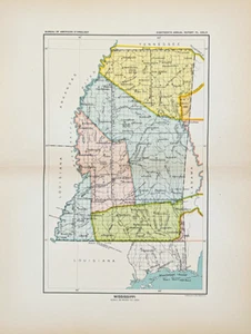
1899 MISSISSIPPI Map ORIGINAL - CEDED INDIAN LANDS - NATIVE AMERICAN (10.5X6.5)

US $34.20
ApproximatelyRM 144.56
or Best Offer
Was US $38.00 (10% off)
Condition:
Oops! Looks like we're having trouble connecting to our server.
Refresh your browser window to try again.
Shipping:
Free USPS Ground Advantage®.
Located in: Carefree, Arizona, United States
Delivery:
Estimated between Thu, 28 Aug and Thu, 4 Sep to 94104
Returns:
30 days return. Seller pays for return shipping.
Coverage:
Read item description or contact seller for details. See all detailsSee all details on coverage
(Not eligible for eBay purchase protection programmes)
Seller assumes all responsibility for this listing.
eBay item number:326721890025
Item specifics
- US State
- Mississippi
- Printing Technique
- Lithography
- Shipping and handling
- FREE SHIPPING IN THE UNITED STATES
- Cartographer/Publisher
- C.C. ROYCE
- City
- JACKSON
- Source of map
- 1899 Report of the Bureau of Ethnology, Washington DC
- Date Range
- 1800-1899
- Type
- Map
- Format
- Atlas Map
- Year
- 1899
- Shows
- Native American Indian Land Cession map
- Original/Reproduction
- Antique Original
- Country/Region
- United States of America
- Age
- Guaranteed 126 year old map
Item description from the seller

Seller feedback (6,400)
- a***r (448)- Feedback left by buyer.Past monthVerified purchaseA+++++++
- e***e (867)- Feedback left by buyer.Past monthVerified purchaseA most delightful purchase! Fast shipping and well protected. Thank you!
- m***n (4337)- Feedback left by buyer.Past monthVerified purchaseexcellent map, good communication
More to explore :
- Antique North American Maps Mississippi 1800-1899 Date Range Atlases,
- Antique North American Maps & Atlases Mississippi,
- Copper Plate Mississippi Antique Original Antique North American Maps & Atlases,
- New Orleans Mississippi Antique Original Antique North American Maps & Atlases,
- Original Native American Antiques,
- Mississippi Antique Original Antique North American Maps & Atlases 1910-1919 Date Range,
- Mississippi Antique Original Antique North America Folding Maps,
- Original 1800-1899 Antique World Maps & Atlases,
- Antique Original 1850-1899 Indian Antique Masks,
- Antique Original 1850-1899 Indian Antique Bowls
Seller feedback (6,400)
- a***r (448)- Feedback left by buyer.Past monthVerified purchaseA+++++++
- e***e (867)- Feedback left by buyer.Past monthVerified purchaseA most delightful purchase! Fast shipping and well protected. Thank you!
- m***n (4337)- Feedback left by buyer.Past monthVerified purchaseexcellent map, good communication