
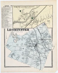
1870 LEOMINSTER - MASSACHUSETTS Map WORCESTER County ORIGINAL (13X10)
US $24.00US $24.00
Aug 13, 01:42Aug 13, 01:42
Picture 1 of 2

Gallery
Picture 1 of 2


Have one to sell?
1870 LEOMINSTER - MASSACHUSETTS Map WORCESTER County ORIGINAL (13X10)

US $24.00
ApproximatelyRM 101.53
or Best Offer
Condition:
“GOOD”
Oops! Looks like we're having trouble connecting to our server.
Refresh your browser window to try again.
Shipping:
Free USPS Ground Advantage®.
Located in: Carefree, Arizona, United States
Delivery:
Estimated between Sat, 16 Aug and Fri, 22 Aug to 94104
Returns:
30 days return. Seller pays for return shipping.
Coverage:
Read item description or contact seller for details. See all detailsSee all details on coverage
(Not eligible for eBay purchase protection programmes)
Seller assumes all responsibility for this listing.
eBay item number:326706038583
Item specifics
- Seller Notes
- “GOOD”
- US State
- Massachusetts
- Printing Technique
- Lithography
- Title page shown for reference only, not included
- shown for reference only, not included
- Color
- Original hand-coloring, Vibrant
- Cartographer/Publisher
- F.W. BEERS & COMPANY
- City
- LEOMINSTER
- Date Range
- 1800-1899
- Type
- Plat map
- Format
- Atlas Map
- Year
- 1870
- Atlas source
- Atlas of Worcester County Massachusetts, 1870
- Original/Reproduction
- Antique Original
- Country/Region
- United States of America
Item description from the seller

Seller feedback (6,387)
- d***k (10)- Feedback left by buyer.Past monthVerified purchaseAccurate description. Superbly packaged and prompt delivery! Well done.
- d***k (10)- Feedback left by buyer.Past monthVerified purchaseAccurate description. Superbly packaged and prompt delivery! Well done.
- i***k (629)- Feedback left by buyer.Past monthVerified purchaseFast service, well packaged and just what I needed. A great piece to take to our family reunion there.
More to explore :
- Massachusetts Antique Original Antique North America County Maps,
- Massachusetts Antique North America County Maps,
- Massachusetts County Map Antique North America Atlas Maps,
- Massachusetts County Map Antique North America Atlas,
- Norfolk Massachusetts Antique North America County Maps,
- Antique Original County Map Antique Sheet Maps,
- Antique Original Antique County Maps,
- Massachusetts 1900-1909 Date Range Antique North America County Maps,
- Antique Original Antique Europe County Maps,
- Antique Original Antique Africa County Maps
Seller feedback (6,387)
- d***k (10)- Feedback left by buyer.Past monthVerified purchaseAccurate description. Superbly packaged and prompt delivery! Well done.
- d***k (10)- Feedback left by buyer.Past monthVerified purchaseAccurate description. Superbly packaged and prompt delivery! Well done.
- i***k (629)- Feedback left by buyer.Past monthVerified purchaseFast service, well packaged and just what I needed. A great piece to take to our family reunion there.