Picture 1 of 4


Gallery
Picture 1 of 4


Have one to sell?
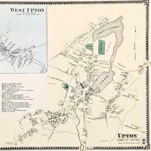
1870 UPTON Township Plat Map WORCESTER County Massachusetts (14x11) ORIGINAL

Condition:
Oops! Looks like we're having trouble connecting to our server.
Refresh your browser window to try again.
Shipping:
Free USPS Ground Advantage®.
Located in: Monroe, Georgia, United States
Delivery:
Estimated between Tue, 5 Aug and Mon, 11 Aug to 94104
Returns:
30 days return. Seller pays for return shipping.
Coverage:
Read item description or contact seller for details. See all detailsSee all details on coverage
(Not eligible for eBay purchase protection programmes)
Seller assumes all responsibility for this listing.
eBay item number:326703610433
Item specifics
- US State
- Massachusetts
- Printing Technique
- Lithography
- Color
- Original hand-coloring
- Cartographer/Publisher
- F. W. Beers & Co.
- City
- UPTON
- Date Range
- 1800-1899
- Type
- Plat Map
- Format
- Atlas Map
- Title page
- Shown for reference only, a copy can be provided, ask at checkout
- Year
- 1870
- Original/Reproduction
- Antique Original
- Atlas Source
- Atlas of Worcester County Massachusetts, 1870
- Country/Region
- United States of America
Item description from the seller

Seller feedback (6,358)
- m***m (4619)- Feedback left by buyer.Past monthVerified purchase6star professional Ebay transaction - secure packaging - rocket fast shipping
- m***m (4619)- Feedback left by buyer.Past monthVerified purchase6star professional Ebay transaction - secure packaging - rocket fast shipping
- m***m (4619)- Feedback left by buyer.Past monthVerified purchase6star professional Ebay transaction - secure packaging - rocket fast shipping
More to explore :
- Massachusetts Antique Original Antique North America County Maps,
- Massachusetts Antique North America County Maps,
- Massachusetts County Map Antique North America Atlas Maps,
- Massachusetts County Map Antique North America Atlas,
- Norfolk Massachusetts Antique North America County Maps,
- Antique Original County Map Antique Atlas Maps,
- Vintage Original County Map Antique Wall Maps,
- Antique Original Antique Asia County Maps,
- Lithography Antique Original Antique County Maps,
- Antique Original County Map Antique Europe Atlas Maps
Seller feedback (6,358)
- m***m (4619)- Feedback left by buyer.Past monthVerified purchase6star professional Ebay transaction - secure packaging - rocket fast shipping
- m***m (4619)- Feedback left by buyer.Past monthVerified purchase6star professional Ebay transaction - secure packaging - rocket fast shipping
- m***m (4619)- Feedback left by buyer.Past monthVerified purchase6star professional Ebay transaction - secure packaging - rocket fast shipping