Picture 1 of 3


Gallery
Picture 1 of 3


Have one to sell?
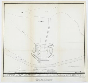
1884 PLAN of FORT MOULTRIE - SOUTH CAROLINA Map Charleston Harbor ORIGINAL

US $45.00
ApproximatelyRM 191.03
or Best Offer
Condition:
Oops! Looks like we're having trouble connecting to our server.
Refresh your browser window to try again.
Shipping:
Free USPS Ground Advantage®.
Located in: Carefree, Arizona, United States
Delivery:
Estimated between Wed, 13 Aug and Mon, 18 Aug to 94104
Returns:
30 days return. Seller pays for return shipping.
Coverage:
Read item description or contact seller for details. See all detailsSee all details on coverage
(Not eligible for eBay purchase protection programmes)
Seller assumes all responsibility for this listing.
eBay item number:326691416944
Item specifics
- Date Range
- 1800-1899
- Type
- Fort Plan map
- Format
- Atlas Map
- Printing Technique
- Lithography
- US State
- South Carolina
- Year
- 1884
- Original/Reproduction
- Antique Original
- Cartographer/Publisher
- City Council of Charleston
- City
- Fort Moultrie
- Country/Region
- United States of America
Item description from the seller

Seller feedback (6,370)
- c***1 (3852)- Feedback left by buyer.Past monthVerified purchaseGreat transaction! Thanks!
- 7***6 (221)- Feedback left by buyer.Past monthVerified purchaseBeautiful map! Safely packaged and arrived quickly. Thank you!
- a***a (82)- Feedback left by buyer.Past monthVerified purchaseHighly recommended
More to explore :
- South Carolina Charleston Antique Original Antique North America Maps & Atlases,
- South Carolina Charleston Antique North America Maps & Atlases,
- South Carolina Charleston Antique North America Atlas Maps,
- Charleston Lithography South Carolina Antique North American Maps & Atlases,
- Charleston United States of America South Carolina Antique North America Maps & Atlases,
- South Carolina Charleston 1800-1899 Date Range Antique North America Maps & Atlases,
- South Carolina Antique Original Antique North America County Maps,
- South Carolina Antique North America Maps & Atlases,
- South Carolina Antique North America County Maps,
- Woodcut South Carolina Antique North America Maps & Atlases
Seller feedback (6,370)
- c***1 (3852)- Feedback left by buyer.Past monthVerified purchaseGreat transaction! Thanks!
- 7***6 (221)- Feedback left by buyer.Past monthVerified purchaseBeautiful map! Safely packaged and arrived quickly. Thank you!
- a***a (82)- Feedback left by buyer.Past monthVerified purchaseHighly recommended