Picture 1 of 3


Gallery
Picture 1 of 3


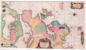
REPRO MAP PRINT 14.2" x 8.2" OF AN ANTIQUE 1715 MAP OF THE COASTS OF EUROPE
GBP 1.79
ApproximatelyRM 10.24
Condition:
“ITEM AS PICTURES PLEASE INSPECT CAREFULLY AS THIS IS THE PRINT YOU WILL RECIEVE.”
Oops! Looks like we're having trouble connecting to our server.
Refresh your browser window to try again.
Delivery:
Varies
Returns:
No returns accepted.
Coverage:
Read item description or contact seller for details. See all detailsSee all details on coverage
(Not eligible for eBay purchase protection programmes)
Seller assumes all responsibility for this listing.
eBay item number:316068763220
Item specifics
- Seller Notes
- “ITEM AS PICTURES PLEASE INSPECT CAREFULLY AS THIS IS THE PRINT YOU WILL RECIEVE.”
- Date Range
- THIS VINTAGE REPRODICTION PUBLISHED IN 1974.
- Type
- REPRODUCTION OF AN ORIGINAL ANTIQUE MAP.
- Format
- ANTIQUE 1715 MAP OF THE COASTS OF EUROPE.
- Original/Reproduction
- Vintage Reproduction
- Cartographer/Publisher
- LOUIS RENARD.
- YES I DO COMBINE POSTAGE PLEASE SEE DETAILS AT END OF LISTING
- MANY MORE MAPS / ITEMS IN MY SHOP PLEASE TAKE A LOOK.
Item description from the seller
Seller feedback (1,788)
- eBay automated Feedback- Feedback left by buyer.Past monthOrder completed successfully – tracked and on time
- a***f (690)- Feedback left by buyer.Past monthVerified purchaseBrilliant thank you so much.
- f***b (3875)- Feedback left by buyer.Past monthVerified purchaseSo 'securely' packaged, it was virtually impossible to retrieve the delicate item without damaging it.
More to explore :
- Geological Map Antique Europe Atlas Maps,
- Antique Europe Political Maps,
- Antique Europe City Maps,
- Physical Map Antique Europe Atlas Maps,
- Political Map Antique Europe Atlas Maps,
- Antique Europe Wall Maps,
- Antique Europe Folding Maps,
- Antique Europe County Maps,
- Antique Europe School Maps,
- Antique Europe River Maps