Picture 1 of 8


Gallery
Picture 1 of 8


Have one to sell?
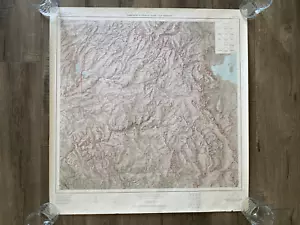
1928 / 1963 Yosemite National Park and Vicinity U.S. Geological Survey Map

US $100.00
ApproximatelyRM 422.70
or Best Offer
Condition:
Oops! Looks like we're having trouble connecting to our server.
Refresh your browser window to try again.
Shipping:
US $18.10 (approx RM 76.51) USPS Ground Advantage®.
Located in: San Bernardino, California, United States
Delivery:
Estimated between Wed, 27 Aug and Tue, 2 Sep to 94104
Returns:
30 days return. Buyer pays for return shipping. If you use an eBay shipping label, it will be deducted from your refund amount.
Coverage:
Read item description or contact seller for details. See all detailsSee all details on coverage
(Not eligible for eBay purchase protection programmes)
Seller assumes all responsibility for this listing.
eBay item number:315278140323
Item specifics
- Date Range
- 1960-1969
- Type
- Topographical Map
- US State
- California
- Format
- Wall Map
- Printing Technique
- Lithography
- Year
- 1963
- Original/Reproduction
- Antique Original
- Cartographer/Publisher
- U.S. Geological Survey
- City
- Yosemite
- Country/Region
- United States of America
Item description from the seller

Popular categories from this store
Seller feedback (4,386)
- 0***s (497)- Feedback left by buyer.Past monthVerified purchaseFast delivery, packaged very well.
- z***_ (104)- Feedback left by buyer.Past monthVerified purchaseGetting monitors is a risk, but the packing was amazing. It´ll get a lot of use.
- 6***r (1491)- Feedback left by buyer.Past monthVerified purchaseGreat Seller/Fast shipping A+
More to explore :
- Antique Geological Maps,
- Antique Ordnance Survey Maps,
- Geological Map Antique Wall Maps,
- Geological Map Antique Atlas Maps,
- Geological Map Antique Folding Maps,
- Antique World Geological Maps,
- Antique Europe Geological Maps,
- Antique North America Geological Maps,
- Lithography Geological Map Antique Folding Maps,
- Geological Map Antique North America Atlas Maps
Popular categories from this store
Seller feedback (4,386)
- 0***s (497)- Feedback left by buyer.Past monthVerified purchaseFast delivery, packaged very well.
- z***_ (104)- Feedback left by buyer.Past monthVerified purchaseGetting monitors is a risk, but the packing was amazing. It´ll get a lot of use.
- 6***r (1491)- Feedback left by buyer.Past monthVerified purchaseGreat Seller/Fast shipping A+