Picture 1 of 24


Gallery
Picture 1 of 24


Have one to sell?
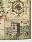
3 x Old Antique Vintage maps Derbyshire, England: 1600's & 1800's: Reprint
GBP 12.00
ApproximatelyRM 68.56
Condition:
“These maps are book plates taken very carefully from 3 different book of maps printed in 1980's and ”... Read moreabout condition
Oops! Looks like we're having trouble connecting to our server.
Refresh your browser window to try again.
Shipping:
GBP 20.26 (approx RM 115.75) International Priority Shipping to United States via eBay's Global Shipping Program.
Located in: Sheffield, United Kingdom
Import charges:
Free amount confirmed at checkout
Delivery:
Estimated between Fri, 1 Aug and Tue, 12 Aug to 94104
Includes international tracking
Returns:
No returns accepted.
Coverage:
Read item description or contact seller for details. See all detailsSee all details on coverage
(Not eligible for eBay purchase protection programmes)
Seller assumes all responsibility for this listing.
eBay item number:305836086275
Item specifics
- Seller Notes
- Antique
- Yes
- Date Range
- 1600-1699
- Type
- County Map
- Format
- Wall/ Poster Map
- Year
- 1610, 1830, 1840
- Era
- 1800s
- Cartographer/Publisher
- John Speed
- Original/Reproduction
- Antique Reproduction
- Country/Region
- England
- County
- Derbyshire
- Map Type
- Countries/ Borders
- Antique/ Modern
- Antique
Item description from the seller
Seller feedback (3,313)
- *****- Feedback left by buyer.Past monthVerified purchaseFast and secure delivery, nice twin book page map of the 16th Century Nation of Scotland. Will look nice framed and hung up on my 18th Century Scottish granite stone house, hallway wall..
- *****- Feedback left by buyer.Past monthVerified purchaseLovely reprint
- *****- Feedback left by buyer.Past monthVerified purchasethank you.
This is a private listing and your identity will not be disclosed to anyone except the seller.
More to explore :
- Antique European Maps & Atlases England 1600-1699 Date Range,
- England 1600-1699 Date Range Antique Europe Folding Maps,
- England 1600-1699 Date Range Antique Europe County Maps,
- England 1800-1899 Date Range Antique Europe Sheet Maps,
- England 1800-1899 Date Range Antique Europe County Maps,
- England Antique Europe Maps & Atlases,
- England European Antique Maps & Atlases Nottinghamshire 1800-1899 Date Range,
- England European Antique Maps & Atlases Dorset 1800-1899 Date Range,
- London Antique European Maps & Atlases England 1800-1899 Date Range,
- England European Antique Maps & Atlases Shropshire 1800-1899 Date Range