
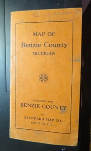
EARLY MAP OF BENZIE COUNTY BY Standard Map Co folding with cover
US $29.99US $29.99
Jul 29, 21:31Jul 29, 21:31
Picture 1 of 4


Gallery
Picture 1 of 4


Have one to sell?
EARLY MAP OF BENZIE COUNTY BY Standard Map Co folding with cover
Condition:
“selling one man's local Michigan postcard collection. Keep watching”
Ended: Jul 29, 2025 21:31:59 MYT
Oops! Looks like we're having trouble connecting to our server.
Refresh your browser window to try again.
Shipping:
US $2.17 (approx RM 9.19) USPS First Class Large Envelope.
Located in: Bear Lake, Michigan, United States
Delivery:
Estimated between Sat, 2 Aug and Fri, 8 Aug to 94104
Returns:
30 days return. Buyer pays for return shipping. If you use an eBay shipping label, it will be deducted from your refund amount.
Coverage:
Read item description or contact seller for details. See all detailsSee all details on coverage
(Not eligible for eBay purchase protection programmes)
Seller assumes all responsibility for this listing.
eBay item number:297487567485
Item specifics
- Seller Notes
- “selling one man's local Michigan postcard collection. Keep watching”
- Type
- County Map
- US State
- Michigan Benzie County
- Format
- Folding Map
- Printing Technique
- Lithography
Item description from the seller
Seller feedback (8,877)
- o***o (4340)- Feedback left by buyer.Past monthVerified purchaseGood communication, quick shipping, item as described. Thanks!
- o***o (4340)- Feedback left by buyer.Past monthVerified purchaseGood communication, quick shipping, item as described. Thanks!
- o***o (4340)- Feedback left by buyer.Past monthVerified purchaseGood communication, quick shipping, item as described. Thanks!
More to explore :
- County Map Antique Folding Maps,
- County Map Antique Europe Folding Maps,
- County Map Antique World Folding Maps,
- Lithography County Map Antique Folding Maps,
- Copper Plate County Map Antique Folding Maps,
- Antique Original County Map Antique World Folding Maps,
- County Map Antique Atlas Maps,
- County Map Antique Sheet Maps,
- New York County Map Antique North America Folding Maps,
- 1930-1939 Date Range County Map Antique Folding Maps