Picture 1 of 2

Gallery
Picture 1 of 2


Have one to sell?
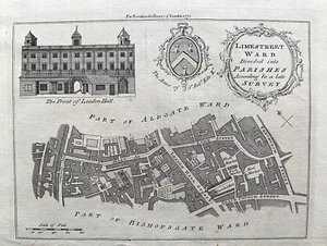
1772 Antique Print; Lime Street Ward London from Noorthouck's London

GBP 49.99
ApproximatelyRM 281.37
Condition:
“Very good, suitable for framing. Please check the scan for any blemishes prior to making your ”... Read moreabout condition
Oops! Looks like we're having trouble connecting to our server.
Refresh your browser window to try again.
Shipping:
GBP 5.20 (approx RM 29.27) Royal Mail International Standard.
Located in: Marlow, United Kingdom
Delivery:
Estimated between Sat, 9 Aug and Fri, 22 Aug to 94104
Returns:
30 days return. Buyer pays for return shipping. If you use an eBay shipping label, it will be deducted from your refund amount.
Coverage:
Read item description or contact seller for details. See all detailsSee all details on coverage
(Not eligible for eBay purchase protection programmes)
Shop with confidence
Seller assumes all responsibility for this listing.
eBay item number:296063987596
Item specifics
- Seller Notes
- Antique
- Yes
- Date Range
- 1700-1799
- Type
- City Map
- Format
- Sheet Map
- Printing Technique
- Copper Plate
- Year
- 1772
- Era
- 1700s
- Original/Reproduction
- Antique Original
- Cartographer/Publisher
- Thomas Bowen
- City
- London
- Country/Region
- United Kingdom
- County
- London
Item description from the seller

Seller feedback (14,208)
- eBay automated Feedback- Feedback left by buyer.Past monthOrder completed successfully – tracked and on time
- eBay automated Feedback- Feedback left by buyer.Past monthOrder completed successfully – tracked and on time
- eBay automated Feedback- Feedback left by buyer.Past monthOrder completed successfully – tracked and on time
More to explore :
- London London Antique Europe County Maps,
- London London Antique Europe Folding Maps,
- London London Antique Europe Sheet Maps,
- Antique European Maps & Atlases London London,
- London London Antique Europe City Maps,
- London England London Antique Europe Maps & Atlases,
- London London Copper Plate Antique Europe Maps & Atlases,
- London Antique European Maps & Atlases London 1700-1799 Date Range,
- London Antique Europe Railroad Maps,
- London Antique Europe County Maps
Seller feedback (14,208)
- eBay automated Feedback- Feedback left by buyer.Past monthOrder completed successfully – tracked and on time
- eBay automated Feedback- Feedback left by buyer.Past monthOrder completed successfully – tracked and on time
- eBay automated Feedback- Feedback left by buyer.Past monthOrder completed successfully – tracked and on time