Picture 1 of 6


Gallery
Picture 1 of 6


Have one to sell?
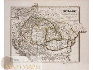
Hungary antique map Ungarn - Hungary and surrounding regions, Karl Spruner 1846

US $115.00
ApproximatelyRM 474.97
or Best Offer
Condition:
“Good antiquarian condition. Exceptionally crisp engraved lines with no foxing or discoloration.”
Oops! Looks like we're having trouble connecting to our server.
Refresh your browser window to try again.
Returns:
No returns accepted.
Coverage:
Read item description or contact seller for details. See all detailsSee all details on coverage
(Not eligible for eBay purchase protection programmes)
About this item
Seller assumes all responsibility for this listing.
eBay item number:286848200253
Item specifics
- Seller Notes
- “Good antiquarian condition. Exceptionally crisp engraved lines with no foxing or discoloration.”
- Date Range
- 1800-1899
- Type
- Political Map
- Format
- Atlas Map
- Printing Technique
- Copper Plate
- Year
- 1846
- Original/Reproduction
- Antique Original
- Cartographer/Publisher
- Adolf Stieler
- City
- Budapest
- Country/Region
- Hungary
Item description from the seller

Seller feedback (611)
- ***** (413)- Feedback left by buyer.Past monthVerified purchaseBeautiful antique Map as described ! Fast shipping, professionally packed, great Value! Amazing Seller AAA+++!!!
- 1***3 (38)- Feedback left by buyer.Past 6 monthsVerified purchaseSeller promptly ànd accurately responded to a question. Map delivered on time. Good value.Quebec City Plan – Canada by Bellin 1757 (#286552390943)
- 7***2 (28)- Feedback left by buyer.Past monthVerified purchaseA map of good condition as described. Thank you for the careful packaging.
More to explore :
- Hungary Antique Europe Political Maps,
- Antique European Maps & Atlases Hungary,
- Hungary Antique Europe City Maps,
- Hungary Antique Europe County Maps,
- Hungary Antique Europe Folding Maps,
- Budapest Hungary Lithography Antique Europe Maps & Atlases,
- Budapest Hungary Antique Original Antique European Maps & Atlases,
- Hungary Copper Plate Antique Europe County Maps,
- Hungary 1700-1799 Date Range Antique Europe County Maps,
- Antique European Maps & Atlases 1500-1599 Date Range Hungary
Seller feedback (611)
- ***** (413)- Feedback left by buyer.Past monthVerified purchaseBeautiful antique Map as described ! Fast shipping, professionally packed, great Value! Amazing Seller AAA+++!!!
- 1***3 (38)- Feedback left by buyer.Past 6 monthsVerified purchaseSeller promptly ànd accurately responded to a question. Map delivered on time. Good value.Quebec City Plan – Canada by Bellin 1757 (#286552390943)
- 7***2 (28)- Feedback left by buyer.Past monthVerified purchaseA map of good condition as described. Thank you for the careful packaging.