Picture 1 of 1
Gallery
Picture 1 of 1

Have one to sell?
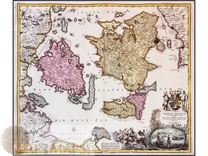
Insvlae Danicae – Denmark Islands Old Map by Johann Baptist Homann, 1720

US $285.00
ApproximatelyRM 1,203.56
or Best Offer
Condition:
“Very good, attractive coloring, minor age imperfections.”
Oops! Looks like we're having trouble connecting to our server.
Refresh your browser window to try again.
Shipping:
US $15.00 (approx RM 63.35) Standard Shipping from outside US.
Located in: Europe, Cyprus
Delivery:
Estimated between Thu, 23 Oct and Thu, 6 Nov to 94104
Returns:
No returns accepted.
Coverage:
Read item description or contact seller for details. See all detailsSee all details on coverage
(Not eligible for eBay purchase protection programmes)
Seller assumes all responsibility for this listing.
eBay item number:286795713660
Item specifics
- Seller Notes
- “Very good, attractive coloring, minor age imperfections.”
- Date Range
- 1700-1799
- Type
- County Map
- Format
- Atlas Map
- Printing Technique
- Copper Plate
- Year
- 1720
- Original/Reproduction
- Antique Original
- Cartographer/Publisher
- Johann Baptist Homann (1663–1724)
- City
- Copenhagen
- Country/Region
- Denmark
Item description from the seller

Seller feedback (607)
- 1***3 (36)- Feedback left by buyer.Past 6 monthsVerified purchaseSeller promptly ànd accurately responded to a question. Map delivered on time. Good value.
- _***5 (2233)- Feedback left by buyer.Past 6 monthsVerified purchaseTutto alla perfezione.
- u***t (1571)- Feedback left by buyer.Past 6 monthsVerified purchaseExcellent sellerDescriptio Livoniae.antique map Estonia Latvia Hondius-Bertius 1629 (#286574169757)
More to explore :
- Johann Baptist Homann Antique Atlas Maps,
- Johann Baptist Homann Antique Topographical Maps,
- Johann Baptist Homann Antique Europe Atlas Maps,
- Johann Baptist Homann Antique Maps, Atlases & Globes,
- Johann Baptist Homann Antique Europe Topographical Maps,
- Antique European Maps & Atlases Johann Baptist Homann,
- Johann Baptist Homann Germany Antique European Maps & Atlases,
- Johann Baptist Homann Antique Original Antique Europe Atlas Maps,
- Johann Baptist Homann Copper Plate Antique Europe Atlas Maps,
- Johann Baptist Homann Antique Original Antique Europe Topographical Maps
Seller feedback (607)
- 1***3 (36)- Feedback left by buyer.Past 6 monthsVerified purchaseSeller promptly ànd accurately responded to a question. Map delivered on time. Good value.
- _***5 (2233)- Feedback left by buyer.Past 6 monthsVerified purchaseTutto alla perfezione.
- u***t (1571)- Feedback left by buyer.Past 6 monthsVerified purchaseExcellent sellerDescriptio Livoniae.antique map Estonia Latvia Hondius-Bertius 1629 (#286574169757)