Picture 1 of 5


Gallery
Picture 1 of 5


Have one to sell?
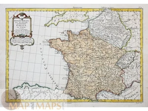
1787 Philippe Map – France Roman Gaul Hand-colored

US $89.95
ApproximatelyRM 380.07
or Best Offer
Condition:
“Good condition. Decorative cartouche, hand coloring, mile scale.”
Oops! Looks like we're having trouble connecting to our server.
Refresh your browser window to try again.
Returns:
No returns accepted.
Coverage:
Read item description or contact seller for details. See all detailsSee all details on coverage
(Not eligible for eBay purchase protection programmes)
Seller assumes all responsibility for this listing.
eBay item number:286792570055
Item specifics
- Seller Notes
- “Good condition. Decorative cartouche, hand coloring, mile scale.”
- Date Range
- 1600-1699
- Type
- County Map
- Format
- Atlas Map
- Printing Technique
- Copper Plate
- Original/Reproduction
- Antique Original
- Cartographer/Publisher
- Philippe de Pretot, Etienne Andre (1710-1787)
- Country/Region
- France
Item description from the seller

Seller feedback (607)
- 1***3 (34)- Feedback left by buyer.Past monthVerified purchaseSeller promptly ànd accurately responded to a question. Map delivered on time. Good value.
- _***5 (2231)- Feedback left by buyer.Past monthVerified purchaseTutto alla perfezione.
- u***t (1563)- Feedback left by buyer.Past 6 monthsVerified purchaseExcellent sellerDescriptio Livoniae.antique map Estonia Latvia Hondius-Bertius 1629 (#286574169757)
More to explore :
- Paris France Antique Maps,
- France City Map Antique Europe Atlas Maps,
- France Topographical Map Antique Europe Atlas Maps,
- France County Map Antique Europe Atlas Maps,
- France Political Map Antique Europe Atlas Maps,
- France Antique Europe School Maps,
- France Antique Europe County Maps,
- Paris France Antique Europe City Maps,
- Paris France Antique Europe County Maps,
- Antique European Maps & Atlases Leipzig France
Seller feedback (607)
- 1***3 (34)- Feedback left by buyer.Past monthVerified purchaseSeller promptly ànd accurately responded to a question. Map delivered on time. Good value.
- _***5 (2231)- Feedback left by buyer.Past monthVerified purchaseTutto alla perfezione.
- u***t (1563)- Feedback left by buyer.Past 6 monthsVerified purchaseExcellent sellerDescriptio Livoniae.antique map Estonia Latvia Hondius-Bertius 1629 (#286574169757)