Picture 1 of 14


Gallery
Picture 1 of 14


Have one to sell?
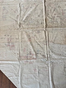
Vintage Hand-Drawn Town Map – West Wyalong NSW – Bland Shire Council –Cadastral
AU $500.00
ApproximatelyRM 1,372.76
or Best Offer
Condition:
Oops! Looks like we're having trouble connecting to our server.
Refresh your browser window to try again.
Shipping:
AU $42.20 (approx RM 115.86) Australia Post International Standard.
Located in: Canberra MC, ACT, Australia
Delivery:
Estimated between Tue, 28 Oct and Thu, 6 Nov to 94104
Returns:
No returns accepted.
Coverage:
Read item description or contact seller for details. See all detailsSee all details on coverage
(Not eligible for eBay purchase protection programmes)
Seller assumes all responsibility for this listing.
eBay item number:286788934331
Item specifics
- Date Range
- 1930-1939
- Type
- County Map
- Format
- Sheet Map
- Year
- 1950
- State/Territory
- New South Wales
- Original/Reproduction
- Antique Original
- Country/Region
- Australia
- Country/Region of Manufacture
- Australia
- Region of Origin
- Australia
- Colour
- Beige
Item description from the seller
Seller feedback (6)
- t***f (1225)- Feedback left by buyer.Past monthVerified purchaseGreat watches, well packaged, good price, good communication, happy customer thanks
- s***t (1167)- Feedback left by buyer.Past 6 monthsVerified purchaseExcellent seller, Super Fast Delivery, 100% Happy, Thanks again
- eBay automated Feedback- Feedback left by buyer.Past 6 monthsOrder delivered on time with no issues
More to explore :
- Manuscript/Hand drawn Antique Sheet Maps,
- Manuscript/Hand drawn Antique County Maps,
- Manuscript/Hand drawn County Map Antique Sheet Maps,
- Manuscript/Hand drawn Antique Maps, Atlases & Globes,
- Manuscript/Hand drawn County Map Antique North America Sheet Maps,
- Antique North American Manuscript/Hand drawn Maps & Atlases,
- Manuscript/Hand drawn Antique North America Sheet Maps,
- United States of America Manuscript/Hand drawn Antique North American Maps & Atlases,
- West Virginia Antique North America Maps & Atlases,
- West Virginia Antique North America County Maps