Picture 1 of 11


Picture 1 of 11


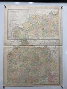
Large Format 1905 COLOR Rand McNally Map Atlas Page 138&139 Railroads Kentucky

US $49.99
ApproximatelyRM 210.21
Condition:
Postage:
US $8.70 (approx RM 36.58) USPS Ground Advantage®.
Located in: Coupland, Texas, United States
Delivery:
Estimated between Thu, 26 Sep and Sat, 28 Sep to 43230
Returns:
30 days return. Seller pays for return shipping.
Coverage:
Read item description or contact seller for details. See all detailsSee all details on coverage
(Not eligible for eBay purchase protection programmes)
Shop with confidence
Seller assumes all responsibility for this listing.
eBay item number:285811189969
Item specifics
- Date Range
- 1899-1904
- Type
- World Atlas
- US State
- Kentucky
- Format
- Atlas Map
- Mexican State
- None
- Printing Technique
- Lithography
- Year
- 1905
- Canadian Province
- None
- Original/Reproduction
- Antique Original
- Cartographer/Publisher
- Rand McNally & Co.
- Country/Region
- United States of America
Item description from the seller

Seller feedback (10,033)
- e***c (755)- Feedback left by buyer.Past monthVerified purchasefast shipping
- h***b (244)- Feedback left by buyer.Past monthVerified purchaseAs described. Would buy from again.
- e***z (2020)- Feedback left by buyer.Past monthVerified purchaseBeautiful lamps, as described and pictured, packaged extremely well, excellent seller, thank you!
More to explore :
- Rand McNally & Co. Antique Atlas Maps,
- Rand McNally & Co. Railroad Map Antique North America Atlas Maps,
- Rand McNally & Co. World Atlas Antique Atlas Maps,
- Rand McNally & Co. Antique Railroad Maps,
- Rand McNally & Co. Antique Asia Atlas Maps,
- Rand McNally & Co. Political Map Antique Atlas,
- Rand McNally & Co. Antique World Atlas Maps,
- Rand McNally & Co. World Atlas Antique Atlas,
- Rand McNally & Co. 1930-1939 Date Range Antique Atlas Maps,
- Rand McNally & Co. 1800-1899 Date Range Antique Atlas Maps