Picture 1 of 7


Gallery
Picture 1 of 7


Have one to sell?
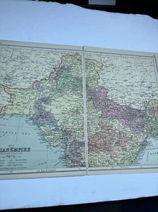
1930: Map Of The Indian Empire Northern Section PA #66/67 Print Political A
GBP 7.50
ApproximatelyRM 42.29
or Best Offer
Condition:
2 available
Oops! Looks like we're having trouble connecting to our server.
Refresh your browser window to try again.
Shipping:
Located in: Evington, Leicestershire, United Kingdom
Delivery:
Varies
Returns:
No returns accepted.
Coverage:
Read item description or contact seller for details. See all detailsSee all details on coverage
(Not eligible for eBay purchase protection programmes)
Seller assumes all responsibility for this listing.
eBay item number:277356253009
Item specifics
- Date Range
- 1930-1939
- Antique
- Yes
- Type
- Physical Map
- Format
- Sheet Map
- Printing Technique
- Lithography
- Year
- 1930
- Original/Reproduction
- Vintage Original
- Country/Region
- Asia
Item description from the seller
Seller feedback (2,083)
- c***e (482)- Feedback left by buyer.Past 6 monthsVerified purchaseA lovely spoon in perfect condition. It is even better than as described and offers great value. The item was packaged carefully and posted promptly. Helpful communication from the seller combined to make this a perfect transaction - many thanks. Highly recommended A++++++++++++Collectors Spoon Benodet Spoon (#277213275318)
- r***c (756)- Feedback left by buyer.Past 6 monthsVerified purchasePetite cartographie du Continent Européen, de l’Atlantique à l’Oural, avant 1914, parfait état, très précise malgré son petit format. Envoi bien protégé et renforcé, soigneusement réalisé. L’objet parvient sécurisé : je remercie le vendeur pour son sérieux et sa fiabilité. Très content de cet achat. Merci.
- o***u (1045)- Feedback left by buyer.Past 6 monthsVerified purchaseBeautiful pictures & lovely frames. Very well packaged and arrived safely and exactly as expected. A1 seller2 x Fiona BUTLER Framed Prints Village Store Decor 11”x 13” Hand Signed gift (#277196872841)
More to explore :
- 1930-1939 Date Range Antique Political Maps,
- Antique Political Maps,
- 1930-1939 Date Range Antique North America Political Maps,
- Antique Asia Political Maps,
- Political Map Antique Atlas Maps,
- Antique Africa Political Maps,
- Hungary Political Map Antique Europe Atlas Maps,
- China Antique Asia Political Maps,
- Palestine Antique Asia Political Maps,
- Antique North America Political Maps