Picture 1 of 14


Gallery
Picture 1 of 14


Have one to sell?
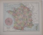
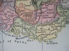
Original 1896 PARIS Street Plan + Engraved View of Eiffel Tower & Map of France

US $22.99
ApproximatelyRM 96.83
Condition:
“SEE BELOW FOR FULL DESCRIPTION. Excellent condition, bright and clean, with no marks, rips, or ”... Read moreabout condition
Oops! Looks like we're having trouble connecting to our server.
Refresh your browser window to try again.
Shipping:
US $6.00 (approx RM 25.27) USPS First Class®.
Located in: Lake Worth, Florida, United States
Delivery:
Estimated between Fri, 22 Aug and Thu, 28 Aug to 94104
Returns:
30 days return. Seller pays for return shipping.
Coverage:
Read item description or contact seller for details. See all detailsSee all details on coverage
(Not eligible for eBay purchase protection programmes)
Seller assumes all responsibility for this listing.
eBay item number:276547720166
Item specifics
- Seller Notes
- Country/Region
- France
- City
- Paris
- Date Range
- 1800-1899
- Original/Reproduction
- Antique Original
- Format
- Atlas Map
- Type
- City Map
- Cartographer/Publisher
- E.M. Fisk
- Printing Technique
- Lithography
- Year
- 1896
- Product Type
- Antique Map
Item description from the seller

Seller feedback (27,100)
- o***l (559)- Feedback left by buyer.Past monthVerified purchaseSafely protected and well packed with multiple sized items such that they all arrived as described. A consistently good Seller over the years.
- o***l (559)- Feedback left by buyer.Past monthVerified purchaseAnother good transaction with New World Maps. Just after a quick review, I was reminded how different the nations of the world were and how much has changed.
- o***l (559)- Feedback left by buyer.Past monthVerified purchaseMap was as described, packed well, and in good condition. A good transaction.
More to explore :
- Paris France Antique Maps,
- Paris France Antique Original Antique European Maps & Atlases,
- Paris France Antique Europe City Maps,
- Paris France Antique Europe Atlas Maps,
- Paris France Antique Europe County Maps,
- Paris France Antique Europe Folding Maps,
- Paris Antique Original Antique Europe Folding Maps,
- Paris France 1900-1909 Date Range Antique Europe Maps & Atlases,
- Paris France 1910-1919 Date Range Antique Europe Maps & Atlases,
- France Antique Original Antique Europe Topographical Maps
Seller feedback (27,100)
- o***l (559)- Feedback left by buyer.Past monthVerified purchaseSafely protected and well packed with multiple sized items such that they all arrived as described. A consistently good Seller over the years.
- o***l (559)- Feedback left by buyer.Past monthVerified purchaseAnother good transaction with New World Maps. Just after a quick review, I was reminded how different the nations of the world were and how much has changed.
- o***l (559)- Feedback left by buyer.Past monthVerified purchaseMap was as described, packed well, and in good condition. A good transaction.