Picture 1 of 12


Gallery
Picture 1 of 12


Have one to sell?
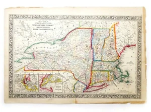
MID-19TH C ANTIQUE 1860 HAND COLORED NEW ENGLAND MAP BY S. AUGUSTUS MITCHELL JR.

US $287.50
ApproximatelyRM 1,217.28
or Best Offer
Condition:
“Good-Very Good overall antique cond: There are a few very slight breaks in the paper which aren't ”... Read moreabout condition
Oops! Looks like we're having trouble connecting to our server.
Refresh your browser window to try again.
Pickup:
Free local pickup from Milford, New Hampshire, United States.
Delivery:
Varies
Returns:
30 days return. Buyer pays for return shipping. If you use an eBay shipping label, it will be deducted from your refund amount.
Coverage:
Read item description or contact seller for details. See all detailsSee all details on coverage
(Not eligible for eBay purchase protection programmes)
Seller assumes all responsibility for this listing.
eBay item number:264455051726
Item specifics
- Seller Notes
- Pre-dates US Civil War
- 19th century hand made American maps
- Printing Technique
- Woodcut
- Mid-19th century
- Circa 1860
- US State
- CT, MA, ME, NH, RI, VT
- American
- Antique
- Cartographer/Publisher
- S. Augustus Mitchell
- Map of New England
- Black woodblock printing ink, watercolor
- Date Range
- 1800-1899
- Hand-colored
- Large folio map
- Dimensions:
- 23 ¾" Width x 15" Height
- Type
- County Map
- Format
- Atlas
- Year
- 1860
- Untouched & undisturbed
- 100% original antique condition (w/old repair)
- Original/Reproduction
- Antique Original
- Country/Region
- United States of America
Item description from the seller

Seller feedback (1,752)
- s***r (213)- Feedback left by buyer.Past monthVerified purchaseBeautiful painting exactly as described. Would happily purchase from seller again.
- b***q (2250)- Feedback left by buyer.Past monthVerified purchaseQuick shipping ! Very well packaged! Item as described! Fair value for market! Great eBayer! Thank you!
- y***t (1913)- Feedback left by buyer.Past monthVerified purchaseLovely piece and fast delivery.very pleased with my purchase. Thank you so much.
More to explore :
- Samuel Augustus Mitchell Antique Atlas Maps,
- Samuel Augustus Mitchell Antique County Maps,
- Samuel Augustus Mitchell Antique Original Antique County Maps,
- Antique European Maps & Atlases Samuel Augustus Mitchell,
- Samuel Augustus Mitchell Lithography Antique Atlas Maps,
- C. Augustus Antique Maps, Atlases & Globes,
- Samuel Augustus Mitchell Woodcut Antique Maps, Atlases & Globes,
- Samuel Augustus Mitchell Antique North America County Maps,
- Samuel Augustus Mitchell Lithography Antique Original Antique Maps, Atlases & Globes,
- Samuel Augustus Mitchell Antique Original Antique Maps, Atlases & Globes 1800-1899 Date Range
Seller feedback (1,752)
- s***r (213)- Feedback left by buyer.Past monthVerified purchaseBeautiful painting exactly as described. Would happily purchase from seller again.
- b***q (2250)- Feedback left by buyer.Past monthVerified purchaseQuick shipping ! Very well packaged! Item as described! Fair value for market! Great eBayer! Thank you!
- y***t (1913)- Feedback left by buyer.Past monthVerified purchaseLovely piece and fast delivery.very pleased with my purchase. Thank you so much.