Picture 1 of 6


Gallery
Picture 1 of 6


Have one to sell?
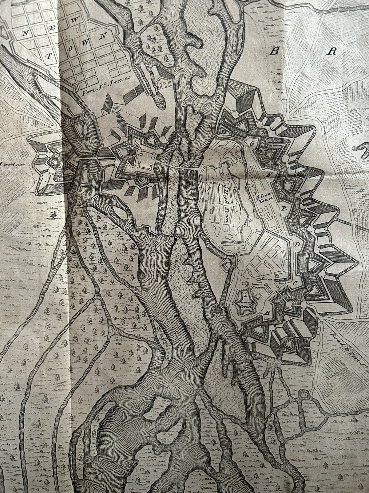
1736 Town Plan Of Breisach, Germany Antique Map by Claude Du Bosc

GBP 40.00
ApproximatelyRM 228.93
or Best Offer
Condition:
“There are a few stains as you would expect on a map of this age but as you can see from the photos ”... Read moreabout condition
Oops! Looks like we're having trouble connecting to our server.
Refresh your browser window to try again.
Returns:
60 days return. Seller pays for return shipping.
Coverage:
Read item description or contact seller for details. See all detailsSee all details on coverage
(Not eligible for eBay purchase protection programmes)
Seller assumes all responsibility for this listing.
eBay item number:257090048737
Item specifics
- Seller Notes
- Date Range
- 1700-1799
- Antique
- Yes
- Type
- Political Map
- Format
- Atlas Map
- Printing Technique
- Copper Plate
- Year
- 1736
- Era
- 1700s
- State
- Baden-Würtemberg
- Cartographer/Publisher
- Claude Du Bosc
- Original/Reproduction
- Antique Original
- City
- Breisach
- Country/Region
- Germany
Item description from the seller

Seller feedback (5,200)
- _***i (589)- Feedback left by buyer.Past monthVerified purchaseApologies for delay,away weekend.Thankyou for sending this delicate item,protected in packaging with Fragile on posting. Its a good historical find,lm goingto get it framed. Many thanks.
- eBay 自動留下信用評價- Feedback left by buyer.Past month訂單成功完成 — 物品享追蹤服務且準時送達
- a***n (44)- Feedback left by buyer.Past monthVerified purchaseGreat purchase, reasonably priced. Item arrived promptly, well packaged and was exactly as described.
More to explore :
- Germany Antique City Maps,
- Antique European Maps & Atlases Germany,
- Germany Antique Europe Physical Maps,
- Germany Antique Europe Geological Maps,
- Germany County Map Antique Europe Atlas Maps,
- Germany Antique Europe Folding Maps,
- Germany Antique Europe Topographical Maps,
- Germany Antique Europe Sheet Maps,
- Germany Saxony Antique Europe Atlas Maps,
- Antique European Maps & Atlases Cologne Germany
Seller feedback (5,200)
- _***i (589)- Feedback left by buyer.Past monthVerified purchaseApologies for delay,away weekend.Thankyou for sending this delicate item,protected in packaging with Fragile on posting. Its a good historical find,lm goingto get it framed. Many thanks.
- eBay 自動留下信用評價- Feedback left by buyer.Past month訂單成功完成 — 物品享追蹤服務且準時送達
- a***n (44)- Feedback left by buyer.Past monthVerified purchaseGreat purchase, reasonably priced. Item arrived promptly, well packaged and was exactly as described.