Picture 1 of 2

Gallery
Picture 1 of 2


Have one to sell?
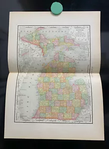
Michigan - c. 1895, Rand McNally & Co., 11 x 14 Antique Map

US $18.50
ApproximatelyRM 78.33
Condition:
Oops! Looks like we're having trouble connecting to our server.
Refresh your browser window to try again.
Shipping:
US $5.95 (approx RM 25.19) USPS Ground Advantage®.
Located in: De Smet, South Dakota, United States
Delivery:
Estimated between Fri, 1 Aug and Thu, 7 Aug to 94104
Returns:
No returns accepted.
Coverage:
Read item description or contact seller for details. See all detailsSee all details on coverage
(Not eligible for eBay purchase protection programmes)
Seller assumes all responsibility for this listing.
eBay item number:256888313300
Item specifics
- Date Range
- 1800-1899
- Format
- Folding Map
- Printing Technique
- Lithography
- US State
- Michigan
- Original/Reproduction
- Antique Original
- Country/Region
- United States of America
Item description from the seller

Seller feedback (2,831)
- e***e (3984)- Feedback left by buyer.Past monthVerified purchaseItem as described. Shipped promptly and packaged well.
- l***u (330)- Feedback left by buyer.Past monthVerified purchaseGood to deal with. Thanks!
- u***j (3664)- Feedback left by buyer.Past monthVerified purchaseThanks
More to explore :
- Michigan Rand McNally & Co. Antique North America Maps & Atlases,
- Rand McNally & Co. Antique Physical Maps,
- Rand McNally & Co. Antique Atlas Maps,
- Rand McNally & Co. Antique City Maps,
- Rand McNally & Co. Antique Railroad Maps,
- Rand McNally & Co. Physical Map Antique Atlas Maps,
- Rand McNally & Co. Antique World Maps & Atlases,
- Rand McNally & Co. Political Map Antique Atlas,
- Rand McNally & Co. Lithography Antique Political Maps,
- Rand McNally & Co. Antique Europe Atlas Maps
Seller feedback (2,831)
- e***e (3984)- Feedback left by buyer.Past monthVerified purchaseItem as described. Shipped promptly and packaged well.
- l***u (330)- Feedback left by buyer.Past monthVerified purchaseGood to deal with. Thanks!
- u***j (3664)- Feedback left by buyer.Past monthVerified purchaseThanks