Picture 1 of 5


Gallery
Picture 1 of 5


Have one to sell?
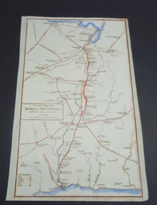
Antique Map of Hadrian's Wall by John Cary 1813

GBP 45.00
ApproximatelyRM 257.27
or Best Offer
Condition:
“Antique Original”
Oops! Looks like we're having trouble connecting to our server.
Refresh your browser window to try again.
Returns:
No returns accepted.
Coverage:
Read item description or contact seller for details. See all detailsSee all details on coverage
(Not eligible for eBay purchase protection programmes)
Seller assumes all responsibility for this listing.
eBay item number:256839446121
Item specifics
- Seller Notes
- “Antique Original”
- Date Range
- 1800-1899
- Type
- Topographical Map
- Printing Technique
- Copper Plate
- Format
- Sheet Map
- Year
- 1813
- Era
- 1800s
- Cartographer/Publisher
- John Cary
- Original/Reproduction
- Antique Original
- Country/Region
- England
Item description from the seller

Seller feedback (491)
- eBay automated feedback- Feedback left by buyer.Past monthOrder completed successfully—tracked and on time
- l***k (7579)- Feedback left by buyer.Past monthVerified purchaseThanks again
- l***k (7579)- Feedback left by buyer.Past monthVerified purchaseThanks again
More to explore :
- John Cary Antique Atlas Maps,
- Antique European Maps & Atlases John Cary,
- John Cary Antique Maps, Atlases & Globes,
- John Cary Antique Europe Atlas Maps,
- John Cary Antique Original Antique Maps, Atlases & Globes,
- Antique Wall Maps,
- Geological Map Antique Wall Maps,
- Nautical Map Antique Wall Maps,
- Antique Original Topographical Map Antique Wall Maps,
- Antique Original County Map Antique Wall Maps
Seller feedback (491)
- eBay automated feedback- Feedback left by buyer.Past monthOrder completed successfully—tracked and on time
- l***k (7579)- Feedback left by buyer.Past monthVerified purchaseThanks again
- l***k (7579)- Feedback left by buyer.Past monthVerified purchaseThanks again