Picture 1 of 5


Gallery
Picture 1 of 5


Have one to sell?
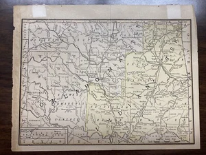
1890 Rand McNally & Co Oklahoma Indian Territory Antique Map Chicago
US $99.95
ApproximatelyRM 423.47
or Best Offer
Condition:
Oops! Looks like we're having trouble connecting to our server.
Refresh your browser window to try again.
Shipping:
US $13.30 (approx RM 56.35) USPS Priority Mail®.
Located in: Enid, Oklahoma, United States
Delivery:
Estimated between Tue, 12 Aug and Mon, 18 Aug to 94104
Returns:
No returns accepted.
Coverage:
Read item description or contact seller for details. See all detailsSee all details on coverage
(Not eligible for eBay purchase protection programmes)
Seller assumes all responsibility for this listing.
eBay item number:255278930387
Item specifics
- Date Range
- 1800-1899
- Type
- County Map
- US State
- Oklahoma
- Format
- Folding Map
- Year
- 1890
- Cartographer/Publisher
- Rand McNally & Co.
- Original/Reproduction
- Unknown
- City
- Chicago
- Country/Region
- United States of America
Item description from the seller
Seller feedback (1,148)
- d***o (378)- Feedback left by buyer.Past monthVerified purchaseGood seller!
- i***0 (342)- Feedback left by buyer.Past monthVerified purchaseVery Happy!🙂
- m***t (46)- Feedback left by buyer.Past monthVerified purchaseAs described and safe packaging
More to explore :
- Rand McNally & Co. Antique Physical Maps,
- Rand McNally & Co. Antique Atlas Maps,
- Rand McNally & Co. Antique City Maps,
- Rand McNally & Co. Antique Railroad Maps,
- Rand McNally & Co. Antique Folding Maps,
- Rand McNally & Co. Antique Wall Maps,
- Rand McNally & Co. Physical Map Antique Atlas Maps,
- Rand McNally & Co. Antique World Wall Maps,
- Rand McNally & Co. Antique Pull Down Maps,
- Rand McNally & Co. Lithography Antique Atlas Maps