Picture 1 of 6


Gallery
Picture 1 of 6


Have one to sell?
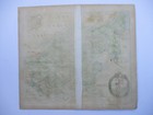
Antique map of Yorkshire West Riding by Richard Blome 1673

GBP 95.00
ApproximatelyRM 536.96
Condition:
Oops! Looks like we're having trouble connecting to our server.
Refresh your browser window to try again.
Shipping:
GBP 5.00 (approx RM 28.26) Royal Mail International Signed.
Located in: Bath, United Kingdom
Delivery:
Estimated between Fri, 24 Oct and Tue, 4 Nov to 94104
Returns:
No returns accepted.
Coverage:
Read item description or contact seller for details. See all detailsSee all details on coverage
(Not eligible for eBay purchase protection programmes)
Seller assumes all responsibility for this listing.
eBay item number:254428254868
Item specifics
- County
- Yorkshire
- Cartographer/Publisher
- Richard Blome
- Printing Technique
- Copper Plate
- Original/Reproduction
- Antique Original
- Type
- Topographical Map
- Year
- 1673
- Date Range
- 1600-1699
- Country/Region
- England
- Era
- 1600s
- Country/Region of Manufacture
- United Kingdom
Item description from the seller

Seller feedback (506)
- Évaluations automatiques eBay- Feedback left by buyer.Past monthCommande livrée dans les délais et sans problème
- e***e (443)- Feedback left by buyer.Past monthVerified purchaseThe map arrived safely in its tube and within a very short time. I have not actually opened it yet as it's a present and the recipient is staying with me, but I'm sure it'll be fine. If not, I'll add another review. Postage was very reasonable and packaging could not have been better. Also, great value for money!
- b***b (1017)- Feedback left by buyer.Past monthVerified purchaseMany thanks for the carefully packed map, which was exactly as described.
More to explore :
- Antique European Maps & Atlases Yorkshire,
- Yorkshire Antique Original Antique European Maps & Atlases,
- Antique European Maps & Atlases England Yorkshire,
- England Yorkshire Antique Original Antique European Maps & Atlases,
- Antique European Maps & Atlases Yorkshire 1800-1899 Date Range,
- England European Antique Maps & Atlases Yorkshire 1800-1899 Date Range,
- West Virginia Antique North America Maps & Atlases,
- West Virginia Vintage Original Antique North America Topographical Maps,
- Antique Atlas Maps,
- Antique Original Political Map Antique Wall Maps
Seller feedback (506)
- Évaluations automatiques eBay- Feedback left by buyer.Past monthCommande livrée dans les délais et sans problème
- e***e (443)- Feedback left by buyer.Past monthVerified purchaseThe map arrived safely in its tube and within a very short time. I have not actually opened it yet as it's a present and the recipient is staying with me, but I'm sure it'll be fine. If not, I'll add another review. Postage was very reasonable and packaging could not have been better. Also, great value for money!
- b***b (1017)- Feedback left by buyer.Past monthVerified purchaseMany thanks for the carefully packed map, which was exactly as described.