Picture 1 of 8


Gallery
Picture 1 of 8


Have one to sell?
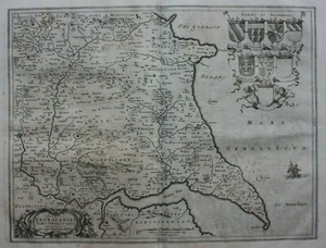
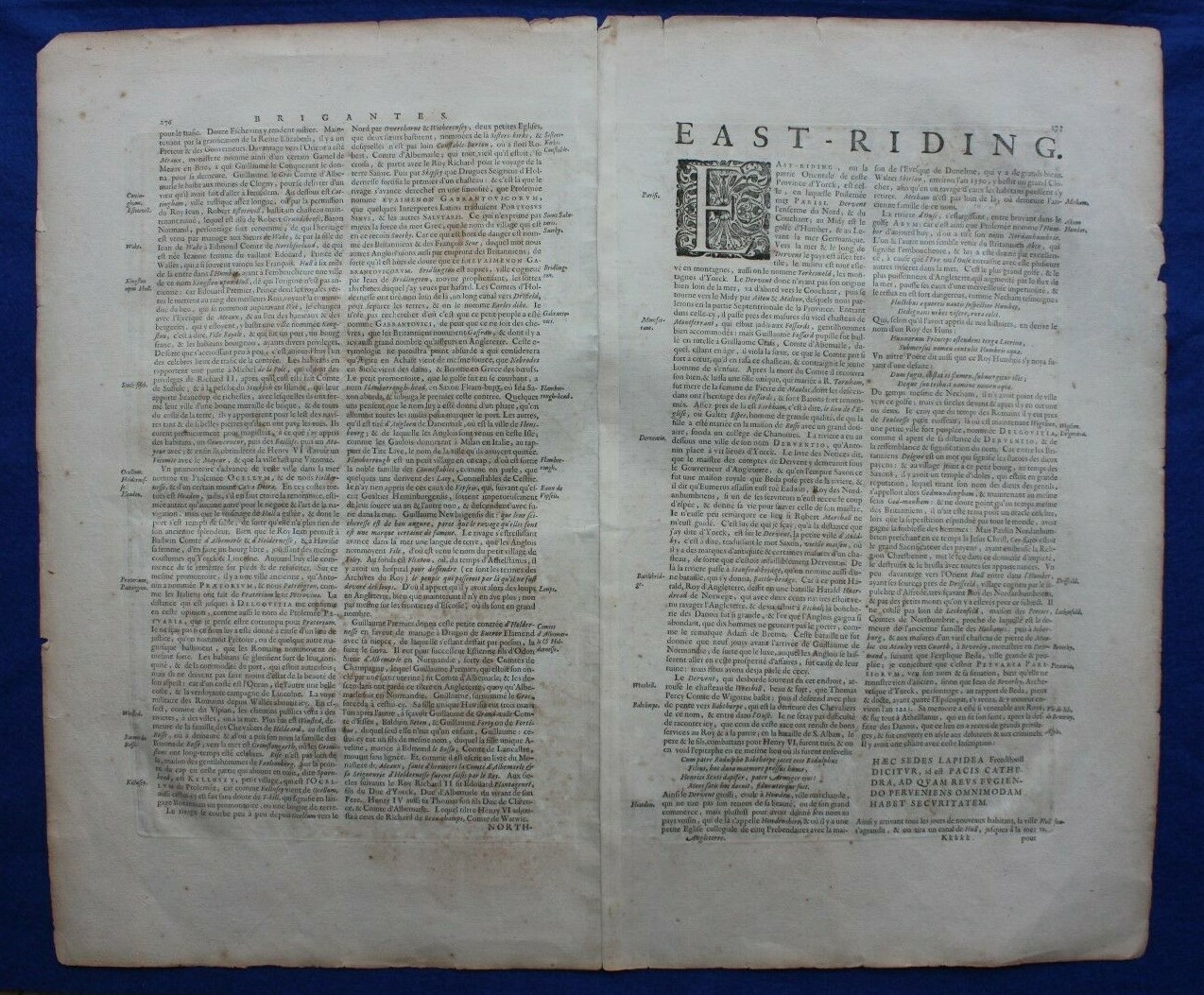
EAST YORKSHIRE antique map, 'DUCATUS EBORACENSIS PARS ORIENTALIS', Blaeu, c.1648

GBP 90.00
ApproximatelyRM 510.61
Condition:
“Very reasonable condition. Age toning and some age spotting. Centrefold as published. Some light ”... Read moreabout condition
Oops! Looks like we're having trouble connecting to our server.
Refresh your browser window to try again.
Shipping:
GBP 14.50 (approx RM 82.27) Economy Int'l Postage.
Located in: Menston, West Yorkshire, United Kingdom
Delivery:
Estimated between Mon, 20 Oct and Fri, 7 Nov to 94104
Ships today if you order in the next 1 hr 40 mins
Returns:
30 days return. Buyer pays for return shipping. If you use an eBay shipping label, it will be deducted from your refund amount.
Coverage:
Read item description or contact seller for details. See all detailsSee all details on coverage
(Not eligible for eBay purchase protection programmes)
Seller assumes all responsibility for this listing.
eBay item number:235507053086
Item specifics
- Seller Notes
- County
- Yorkshire
- Cartographer/Publisher
- J. Blaeu
- Printing Technique
- Copper Plate
- Date Range
- 1600-1699
- Original/Reproduction
- Antique Original
- Country/Region
- England, United Kingdom
- Era
- 1600s
- Format
- Atlas Map
- Type
- Atlas Map
- Year
- c.1648
Item description from the seller

Seller feedback (2,574)
- u***z (690)- Feedback left by buyer.Past monthVerified purchaseShipping - super fast. Packaging - professionally packed. Item - as described and in superb condition. Value - worth buying it. Trusted seller and business done smoothly.
- e***a (76)- Feedback left by buyer.Past 6 monthsVerified purchaseI am giving this purchase a 5-star rating, even though the map arrived more than a month late & the shipping tube had been severely mangled (no damage to the contents). Neither problem was the Seller's fault. The shipment was held by US Customs for a month (visible on the tracking documents) without explanation or contact. Seller remained in regular contact, offered to, and then refunded full purchase price during this hiatus. Upon successful delivery, Seller re-invoiced for the map, & I paid.Original antique atlas map BRITISH ISLES, GREAT BRITAIN, IRELAND, E Bowen, 1747 (#335916077525)
- 1***1 (704)- Feedback left by buyer.Past 6 monthsVerified purchaseReceived very quickly and well packaged. Item as described, excellent seller.N. IRELAND, NEWRY, CASTLEWELLAN, DUNDRUM antique road map, Taylor & Skinner 1778 (#336019391147)
More to explore :
- Willem Blaeu Antique County Maps,
- Willem Blaeu Antique Folding Maps,
- Antique European Maps & Atlases Willem Blaeu,
- Willem Blaeu Antique Maps, Atlases & Globes,
- Willem Blaeu Antique Original Antique County Maps,
- Willem Blaeu Antique World County Maps,
- Willem Blaeu Antique Original Antique Folding Maps,
- Antique European Maps & Atlases England Yorkshire,
- Middle East Antique Asia Maps & Atlases,
- Willem Blaeu Antique World Maps & Atlases 1600-1699 Date Range
Seller feedback (2,574)
- u***z (690)- Feedback left by buyer.Past monthVerified purchaseShipping - super fast. Packaging - professionally packed. Item - as described and in superb condition. Value - worth buying it. Trusted seller and business done smoothly.
- e***a (76)- Feedback left by buyer.Past 6 monthsVerified purchaseI am giving this purchase a 5-star rating, even though the map arrived more than a month late & the shipping tube had been severely mangled (no damage to the contents). Neither problem was the Seller's fault. The shipment was held by US Customs for a month (visible on the tracking documents) without explanation or contact. Seller remained in regular contact, offered to, and then refunded full purchase price during this hiatus. Upon successful delivery, Seller re-invoiced for the map, & I paid.Original antique atlas map BRITISH ISLES, GREAT BRITAIN, IRELAND, E Bowen, 1747 (#335916077525)
- 1***1 (704)- Feedback left by buyer.Past 6 monthsVerified purchaseReceived very quickly and well packaged. Item as described, excellent seller.N. IRELAND, NEWRY, CASTLEWELLAN, DUNDRUM antique road map, Taylor & Skinner 1778 (#336019391147)