Picture 1 of 6


Gallery
Picture 1 of 6


Have one to sell?
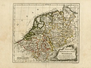
Antique Map-MAP-NETHER

US $219.50
ApproximatelyRM 923.88
or Best Offer
Condition:
“Good, given age. Ample margins, central fold, fold strenghtened at bottom margin. Small tear in ”... Read moreabout condition
Oops! Looks like we're having trouble connecting to our server.
Refresh your browser window to try again.
Shipping:
US $29.95 (approx RM 126.06) FedEx International Economy from Abroad.
Located in: Zeeland, Netherlands
Delivery:
Estimated between Wed, 15 Oct and Wed, 22 Oct
Returns:
30 days return. Buyer pays for return shipping. If you use an eBay shipping label, it will be deducted from your refund amount.
Coverage:
Read item description or contact seller for details. See all detailsSee all details on coverage
(Not eligible for eBay purchase protection programmes)
Shop with confidence
Seller assumes all responsibility for this listing.
eBay item number:235500113887
Item specifics
- Seller Notes
- Artist
- F. Dussy & J. Arrivet
- Subject
- Maps
- Medium
- Engraving
- Features
- Plate signed
- Style
- Realism
- Size
- Small
- Height (Inches)
- 11.4
- Width (Inches)
- 16.5
- Width (Centimeters)
- 42.0
- Orientation
- Landscape
- Type
- Topographical Map
- Culture
- European
- Material
- Paper
- Original/Licensed Reprint
- Original
- Production Technique
- Engraving
- Region of Origin
- Europe
- Theme
- Topographical
- Year of Production
- 1780
- Framing
- Unframed
- Image Orientation
- Landscape
- Unit of Sale
- Single Piece
- Height (Centimeters)
- 29.0
- Item Length
- Not applicable
- Country/Region of Manufacture
- Europe
- Time Period Produced
- 1750-1799
- Item Height
- 16.5 in
- Item Width
- 11.4 in
- Country/Region
- Netherlands and Belgium
- City
- Not applicable
- Date Range
- 1700-1799
- Original/Reproduction
- Antique Original
- Format
- Atlas Map
- Cartographer/Publisher
- Robert de Vaugondy
- Printing Technique
- Copper Plate
- Year
- 1780
- Publisher
- Robert de Vaugondy
- Signed
- Plate signed
- Color
- Multi-Color
- County
- Not applicable
Item description from the seller
Seller business information
VAT number: NL 820763196B01

Popular categories from this store
Seller feedback (8,608)
- t***e (761)- Feedback left by buyer.Past monthVerified purchaseThoughtful and professional seller. Packaged very well. Shipped immediately, arrived quickly. Lovely artworks. Thank you.
- e***a (151)- Feedback left by buyer.Past monthVerified purchaseFast International Shipping, Secure Packaging, Item as described, Great communication, great seller, thank you!
- n***n (273)- Feedback left by buyer.Past monthVerified purchasePerfect transaction. Many thanks!
More to explore :
- Belgium City Map Antique Europe Atlas Maps,
- Belgium County Map Antique Europe Atlas Maps,
- Belgium Political Map Antique Europe Atlas Maps,
- Netherlands City Map Antique Europe Sheet Maps,
- Antique European Maps & Atlases Netherlands,
- Belgium Antique Europe County Maps,
- Belgium Antique Europe Topographical Maps,
- Belgium Antique Europe Folding Maps,
- Antique European Maps & Atlases Germany,
- Antique European Maps & Atlases Bruges Belgium
Popular categories from this store
Seller feedback (8,608)
- t***e (761)- Feedback left by buyer.Past monthVerified purchaseThoughtful and professional seller. Packaged very well. Shipped immediately, arrived quickly. Lovely artworks. Thank you.
- e***a (151)- Feedback left by buyer.Past monthVerified purchaseFast International Shipping, Secure Packaging, Item as described, Great communication, great seller, thank you!
- n***n (273)- Feedback left by buyer.Past monthVerified purchasePerfect transaction. Many thanks!