Picture 1 of 4


Gallery
Picture 1 of 4


Have one to sell?
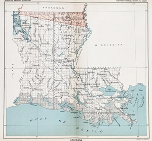
1899 LOUISIANA Map ORIGINAL ANTIQUE - CEDED INDIAN TREATY LANDS (10X9)

US $40.00
ApproximatelyRM 165.29
or Best Offer
Condition:
“GOOD”
Oops! Looks like we're having trouble connecting to our server.
Refresh your browser window to try again.
Shipping:
Free USPS Ground Advantage®.
Located in: Carefree, Arizona, United States
Delivery:
Estimated between Mon, 1 Dec and Sat, 6 Dec to 94104
Ships today if you order in the next 5 hrs 49 mins
Returns:
30 days return. Seller pays for return shipping.
Coverage:
Read item description or contact seller for details. See all detailsSee all details on coverage
(Not eligible for eBay purchase protection programmes)
About this item
Seller assumes all responsibility for this listing.
eBay item number:227087057533
Item specifics
- Seller Notes
- “GOOD”
- Country of Origin
- United States
- Printing Technique
- Lithography
- US State
- Louisiana
- Shipping and handling
- FREE SHIPPING IN THE UNITED STATES
- Cartographer/Publisher
- C.C. ROYCE, WASH. DC
- City
- New Orleans
- Source of map
- 1899 Report of the Bureau of Ethnology, Washington DC
- Date Range
- 1800-1899
- Type
- Map
- Format
- Atlas Map
- Year
- 1899
- Shows
- Native American Indian Land Cession map
- Original/Reproduction
- Antique Original
- Country/Region
- United States of America
- Age
- Guaranteed 126 year old map
Item description from the seller

Seller feedback (6,733)
- n***n (147)- Feedback left by buyer.Past 6 monthsVerified purchaseI was excited to find the lithograph of Mrs. Ann (Taylor) Reeve, the aunt of my 4th great grandmother. Thank you SELSA84 for making these beautiful pictures available. It was shipped immediately In a couple of days was able to open a well secured cylinder package with the picture inside, 10x better then described and pictured online. Priced very reasonably, but priceless to me. Thank you.
- 3***3 (857)- Feedback left by buyer.Past 6 monthsVerified purchaseThe map is exactly as described, fast mailing by seller, Great Communications and over the top packaging. A+++++ eBayer Thank you The USPS Not so much
- _***c (140)- Feedback left by buyer.Past 6 monthsVerified purchaseGreat Ebay Seller! My antique map of Colorado arrived in perfect condition ~ Item was as described ~ Item was packaged well ~ Seller combined shipping cost of 4 historical maps purchased ~ Great Value ~ Transaction deserves 5 STARS! Again, thank you.1885 MAP COLORADO - Original (12x9) GEORGE CRAM - Townships Railroads (#226803088841)
More to explore :
- Louisiana Antique Original Antique North American Maps & Atlases 1800-1899 Date Range,
- Antique Original 1850-1899 Indian Antiques,
- Louisiana Antique Original Antique North America Political Maps,
- Louisiana Antique Original Antique North America Folding Maps,
- Louisiana Antique Original Antique North America Sheet Maps,
- Copper Antique Original 1850-1899 Indian Antiques,
- Antique Original 1850-1899 Indian Antique Figurines,
- Antique Original 1850-1899 Indian Antique Bowls,
- Antique Original 1850-1899 Vase Indian Antiques,
- Antique Original 1850-1899 Bell Indian Antiques
Seller feedback (6,733)
- n***n (147)- Feedback left by buyer.Past 6 monthsVerified purchaseI was excited to find the lithograph of Mrs. Ann (Taylor) Reeve, the aunt of my 4th great grandmother. Thank you SELSA84 for making these beautiful pictures available. It was shipped immediately In a couple of days was able to open a well secured cylinder package with the picture inside, 10x better then described and pictured online. Priced very reasonably, but priceless to me. Thank you.
- 3***3 (857)- Feedback left by buyer.Past 6 monthsVerified purchaseThe map is exactly as described, fast mailing by seller, Great Communications and over the top packaging. A+++++ eBayer Thank you The USPS Not so much
- _***c (140)- Feedback left by buyer.Past 6 monthsVerified purchaseGreat Ebay Seller! My antique map of Colorado arrived in perfect condition ~ Item was as described ~ Item was packaged well ~ Seller combined shipping cost of 4 historical maps purchased ~ Great Value ~ Transaction deserves 5 STARS! Again, thank you.1885 MAP COLORADO - Original (12x9) GEORGE CRAM - Townships Railroads (#226803088841)