Picture 1 of 4


Gallery
Picture 1 of 4


Have one to sell?
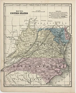
1860 VIRGINIA - NORTH CAROLINA - MARYLAND Map ORIGINAL (10X8.5) RAILROADS

US $34.00
ApproximatelyRM 143.04
or Best Offer
Condition:
“GOOD CONDITION, DISCOLORATION, TEXT ON REVERSE”
Oops! Looks like we're having trouble connecting to our server.
Refresh your browser window to try again.
Shipping:
Free USPS Ground Advantage®.
Located in: Carefree, Arizona, United States
Delivery:
Estimated between Sat, 4 Oct and Fri, 10 Oct to 94104
Returns:
30 days return. Seller pays for return shipping.
Coverage:
Read item description or contact seller for details. See all detailsSee all details on coverage
(Not eligible for eBay purchase protection programmes)
Seller assumes all responsibility for this listing.
eBay item number:226971138848
Item specifics
- Seller Notes
- “GOOD CONDITION, DISCOLORATION, TEXT ON REVERSE”
- Date Range
- 1800-1899
- Type
- Map
- Format
- Atlas Map
- Printing Technique
- Lithography
- US State
- Delaware, Maryland, North Carolina, Virginia, West Virginia
- Year
- 1860
- Original/Reproduction
- Antique Original
- Cartographer/Publisher
- Daniel Burgess
- City
- Washington
- Country/Region
- United States of America
- Country/Region of Manufacture
- United States
Item description from the seller

Seller feedback (6,542)
- w***p (26)- Feedback left by buyer.Past monthVerified purchaseCame as described and in good packaging!
- eBay 自動留下信用評價- Feedback left by buyer.Past month訂單準時送達,沒遇到任何問題
- m***l (2014)- Feedback left by buyer.Past monthVerified purchaseSmooth transaction. Accurate description. Secure packaging. Fast delivery
More to explore :
- Maryland Antique North America Railroad Maps,
- Virginia Antique North America Railroad Maps,
- North Carolina Antique North America Railroad Maps,
- South Carolina Antique Original Antique North America Railroad Maps,
- West Virginia Antique North America Railroad Maps,
- South Carolina Antique North America Railroad Maps,
- Maryland Vintage Original Antique North America Atlas Maps,
- North Carolina Antique Original Antique North America Folding Maps,
- North Carolina Antique North America Maps & Atlases,
- Maryland 1800-1899 Date Range Antique North America Railroad Maps
Seller feedback (6,542)
- w***p (26)- Feedback left by buyer.Past monthVerified purchaseCame as described and in good packaging!
- eBay 自動留下信用評價- Feedback left by buyer.Past month訂單準時送達,沒遇到任何問題
- m***l (2014)- Feedback left by buyer.Past monthVerified purchaseSmooth transaction. Accurate description. Secure packaging. Fast delivery