Picture 1 of 2

Gallery
Picture 1 of 2


Have one to sell?
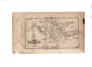
Antique1847 Map Of Portsmouth Harbor New Hampshire by Edmund M. Blunt

US $129.99
ApproximatelyRM 556.12
or Best Offer
Condition:
Oops! Looks like we're having trouble connecting to our server.
Refresh your browser window to try again.
Shipping:
US $8.90 (approx RM 38.08) USPS Ground Advantage®.
Located in: North Las Vegas, Nevada, United States
Delivery:
Estimated between Wed, 6 Aug and Sat, 9 Aug to 94104
Returns:
30 days return. Buyer pays for return shipping. If you use an eBay shipping label, it will be deducted from your refund amount.
Coverage:
Read item description or contact seller for details. See all detailsSee all details on coverage
(Not eligible for eBay purchase protection programmes)
Seller assumes all responsibility for this listing.
eBay item number:226723152111
Item specifics
- US State
- New Hampshire
- Year
- 1847
- Color
- Beige, Black
- City
- Portsmouth
Item description from the seller

Seller feedback (1,970)
- l***m (1191)- Feedback left by buyer.Past monthVerified purchaseSatisfactory Transaction
- l***m (1191)- Feedback left by buyer.Past monthVerified purchaseSatisfactory Transaction
- e***f (402)- Feedback left by buyer.Past monthVerified purchaseThe postcard arrived in perfect condition and quickly. Thank you!
More to explore :
- Antique North American Maps & Atlases New Hampshire,
- New Hampshire Antique North America Wall Maps,
- New Hampshire Topographical Map Antique North America Folding Maps,
- New Hampshire Topographical Map Antique North America Sheet Maps,
- New Hampshire Antique North America Folding Maps,
- New Hampshire Antique North America Political Maps,
- New Hampshire Antique North America Topographical Maps,
- Lithography New Hampshire Antique North America Atlas Maps,
- New Hampshire Contemporary Antique North America Maps & Atlases,
- Lithography New Hampshire Antique North America Maps & Atlases
Seller feedback (1,970)
- l***m (1191)- Feedback left by buyer.Past monthVerified purchaseSatisfactory Transaction
- l***m (1191)- Feedback left by buyer.Past monthVerified purchaseSatisfactory Transaction
- e***f (402)- Feedback left by buyer.Past monthVerified purchaseThe postcard arrived in perfect condition and quickly. Thank you!