Picture 1 of 3


Gallery
Picture 1 of 3


Have one to sell?
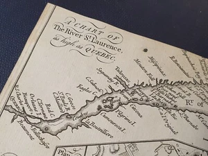
Antique Map Plan Chart St Laurence River Quebec Canada North America 1758

GBP 95.00
ApproximatelyRM 537.81
or Best Offer
Condition:
Oops! Looks like we're having trouble connecting to our server.
Refresh your browser window to try again.
Shipping:
Located in: Leyburn, United Kingdom
Delivery:
Varies
Returns:
No returns accepted.
Coverage:
Read item description or contact seller for details. See all detailsSee all details on coverage
(Not eligible for eBay purchase protection programmes)
Seller assumes all responsibility for this listing.
eBay item number:226424289645
Item specifics
- Antique
- Yes
- Date Range
- 1700-1799
- Type
- Topographical Map
- Format
- Sheet Map
- Year
- 1758
- Canadian Province
- Quebec
- Era
- 1700s
- Cartographer/Publisher
- Unknown
- Original/Reproduction
- Antique Original
- City
- Quebec City
- Country/Region
- Canada
Item description from the seller

Seller feedback (3,139)
- eBay automated Feedback- Feedback left by buyer.Past monthOrder completed successfully – tracked and on time
- eBay automated Feedback- Feedback left by buyer.Past monthOrder completed successfully – tracked and on time
- eBay automated Feedback- Feedback left by buyer.Past monthOrder completed successfully – tracked and on time
More to explore :
- Quebec Canada Antique North America Railroad Maps,
- Quebec Canada Antique North America Maps & Atlases,
- Quebec Canada Antique North America Atlas Maps,
- Quebec Canada Antique North America City Maps,
- Quebec Montreal Canada Antique North America Maps & Atlases,
- River Map Antique North America Sheet Maps,
- Virginia Antique North America River Maps,
- Mississippi Antique North America River Maps,
- Contemporary Antique North America River Maps,
- Savannah Antique North America River Maps
Seller feedback (3,139)
- eBay automated Feedback- Feedback left by buyer.Past monthOrder completed successfully – tracked and on time
- eBay automated Feedback- Feedback left by buyer.Past monthOrder completed successfully – tracked and on time
- eBay automated Feedback- Feedback left by buyer.Past monthOrder completed successfully – tracked and on time