Picture 1 of 3


Gallery
Picture 1 of 3


Have one to sell?
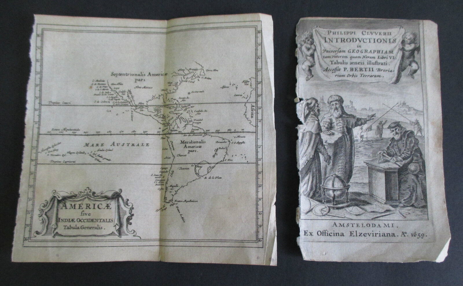
1659 Cluver Map AMERICAE (Americas & West Indies)

US $104.97
ApproximatelyRM 443.29
Was US $149.95 (30% off)
Condition:
“Very light extremity wear; light browning along vertical centerfold, otherwise solid and clean in EX ”... Read moreabout condition
Sale ends in: 23h 15m
Oops! Looks like we're having trouble connecting to our server.
Refresh your browser window to try again.
Shipping:
US $16.60 (approx RM 70.10) USPS Priority Mail®.
Located in: Kingston, New York, United States
Delivery:
Estimated between Sat, 18 Oct and Fri, 24 Oct to 94104
Returns:
30 days return. Buyer pays for return shipping. If you use an eBay shipping label, it will be deducted from your refund amount.
Coverage:
Read item description or contact seller for details. See all detailsSee all details on coverage
(Not eligible for eBay purchase protection programmes)
Seller assumes all responsibility for this listing.
eBay item number:221958469916
Item specifics
- Seller Notes
- Cartographer/Publisher
- Philippi Cluver
- Printing Technique
- Copper Plate
- Original/Reproduction
- Original
- Maker
- Culver
- Format
- Folding Map
- Type
- Map
- Year
- 1659
- Date Range
- 1600-1699
Item description from the seller

Popular categories from this store
Seller feedback (25,626)
- eBay 自動留下信用評價- Feedback left by buyer.Past month訂單準時送達,沒遇到任何問題
- eBay 自動留下信用評價- Feedback left by buyer.Past month訂單準時送達,沒遇到任何問題
- s***s (1707)- Feedback left by buyer.Past monthVerified purchaseAs described. Quick shipping.
More to explore :
- United States of America West Virginia Antique North America Maps & Atlases,
- United States of America West Virginia Antique North America Topographical Maps,
- West Virginia Antique North America Maps & Atlases,
- West Virginia Antique North America Atlas Maps,
- West Virginia Antique North America Folding Maps,
- West Virginia Antique North America County Maps,
- West Virginia Antique North America Topographical Maps,
- Richmond West Virginia Antique North America Maps & Atlases,
- Antique North America Maps & Atlases,
- United States of America Political Map Antique North America Folding Maps
Popular categories from this store
Seller feedback (25,626)
- eBay 自動留下信用評價- Feedback left by buyer.Past month訂單準時送達,沒遇到任何問題
- eBay 自動留下信用評價- Feedback left by buyer.Past month訂單準時送達,沒遇到任何問題
- s***s (1707)- Feedback left by buyer.Past monthVerified purchaseAs described. Quick shipping.